


An all new edition of the ABC 33/40 Weather Xtreme video is available in the player on the right sidebar of the blog. You can subscribe to the Weather Xtreme video on iTunes by clicking here.
MILD WINTER DAY: It is as warm as 78 degrees in Alabama today… Montgomery hit that figure at 2:00 p.m. Mobile is at 77, and we see temperatures across North-Central Alabama are mostly in the 67-71 degree range at mid-afternoon. The air is moist, but no rain is showing up at mid-afternoon. A few showers could pop up tonight, but they will be widely spaced.
SEVERE STORM RISK TOMORROW NIGHT: Tomorrow promises to be a warm, windy day. The GFS model continues to print a high of 75 degrees for Birmingham, within three degrees of the record high for February 20 (78 set in 1986). A few scattered showers are possible during the day, but the main threat from strong storms will come tomorrow night.
No real change in the SPC convective outlook for tomorrow night… much of Alabama is in the standard “slight risk”.
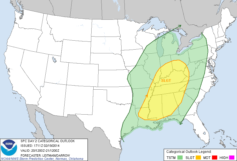
The higher severe weather probabilities are over North and West Alabama, generally along and north of I-59.
TIMING: A line of strong to severe thunderstorms will enter the northwest corner of Alabama around 6:00 p.m., and will move steadily to the southeast during the night. The line should be in the Tuscaloosa/Birmingham/Anniston/Gadsden area in the 9-11 p.m. time frame. The line of storms will exit Alabama and move into Georgia soon after midnight.
MODES OF SEVERE WEATHER: New model data continues to support the idea that the main threat will come from strong straight line wind gusts. The good news is that the projected low level jet speeds (winds around 5,000 feet off the ground) have come down a bit… in the 40-50 knot range over North Alabama. Still, we could see some wind gusts to over 50 mph in segments of the line, and it might be enough to knock down some trees and power lines.
Low level bulk shear values have also come down a bit, but we might see an isolated tornado in a few spots if there are breaks or bows in the line. The overall tornado threat, however, remains low.
FRIDAY/SATURDAY: These days look very nice with ample sunshine and pleasant afternoon temperatures. The high Friday will be in the low 60s; Saturday will be warmer with upper 60s likely.
SUNDAY: A wave in the Gulf will bring clouds back into Alabama, and a chance of rain mainly for the southern half of the state. We are finally getting some good model consistency making for a higher confidence forecast. Best chance of rain Sunday should be along and south of U.S. 80, or south of a line from Demopolis to Montgomery to Auburn/Opelika.
NEXT WEEK: The week looks generally rain-free, but a shot of colder air will invade Alabama Tuesday night and Wednesday. Looks like the high around here will drop into the 40s Wednesday with a chilly north wind. Way too early to even think about putting away winter jackets.
WEATHER BRAINS: Don’t forget you can listen to our weekly 90 minute netcast anytime on the web, or on iTunes. This is the show all about weather featuring many familiar voices, including our meteorologists here at ABC 33/40.
CONNECT: You can find me on all of the major social networks…
Facebook
Twitter
Google Plus
Instagram
I had a great time today visiting with the 2nd graders at Meadow View Elementary in Alabaster… be looking for those kids on the Pepsi KIDCAM today at 5:00 on ABC 33/40 News! The next Weather Xtreme video will be posted here by 7:00 a.m. tomorrow…



