Good Sunday morning, and happy Memorial Day weekend. This is my last briefing for a couple of weeks — Emily flies back from London today and joins us in studio tomorrow, Drew is back in the rotation, and I will be away next weekend. So let me give you the picture before I go.
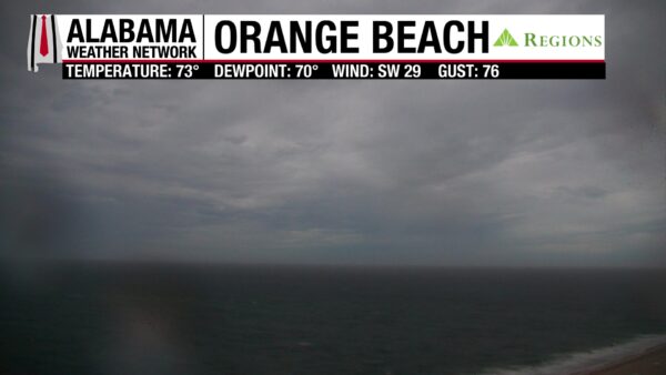
It is a soupy start. Pea soup fog is parked over Huntsville, 66 degrees and 100% relative humidity atop Monte Sano, and the Regions SkyCam Network looked thick almost everywhere — Wethingsville Park at 69 with a dewpoint of 68, Jasper at 68 over 68, Birmingham 70 with a dewpoint of 68. Visibilities have been as low as one mile at Alex City and Montgomery this morning. The bigger headline overnight, though, was down on the coast. A line of strong storms crossed Mobile and Baldwin counties, the Orange Beach camera caught a 76 mph wind gust, Dauphin Island registered 53 mph, and a severe thunderstorm warning was issued for southern Mobile County before the cells weakened moving inland.
The pattern is built for repeated rounds of rain. The subtropical ridge anchored off the Southeast coast is acting as a giant moisture pump, pulling precipitable water values up to 1.8 to 2 inches — that is the top of the scale. A trough to our west tries to close off a small upper level low through Memorial Day, ridging tries to build in by Thursday but the moisture stays trapped underneath, and another trough digs back in on Saturday with a slightly negative tilt. By the end of the period we flip into northwesterly flow and cooler air finally arrives.
The TAMKO HailGuard Severe Weather Outlook for today puts the southeastern third of Alabama under a marginal level one out of five risk — Auburn south to Greenville, Monroeville and Mobile and points southeast. Monday brings no organized severe risks, and Tuesday the severe threat shifts to West Texas. The bigger story for Alabama is flooding. The Weather Prediction Center has us in a level two flash flood risk today, Monday and Tuesday. Turn around, don’t drown — please do not drive into flooded roadways.
Memorial Day Monday will be wet, but it will not be a washout. You will get your activities in if you keep an eye to the sky and to your AWN app. Rounds of showers and storms continue every day this week through Friday, and likely into Saturday. The rainfall outlook is gratifying overall — we need it before we get into the dry stretch of summer — but the five-plus inch ensemble amounts over Southwest Alabama are a little concerning. The ensembles are showing 5 to 7 inches, and even 7 to 10 inches, over north central Mobile County up Highway 43 through Axis, Satsuma and Creola, where the ground is already saturated from this past week.
Week two looks drier. By Monday, June 1, we may see only widely scattered showers, and the long range trends cooler — highs of 76 next Monday, 76 Tuesday, 77 Wednesday, with overnight lows in the lower 60s. The European model is also hinting at a possible tropical system trying to spin up in the eastern Gulf, crossing the Florida peninsula and out into the southwestern Atlantic. Worth watching, but not bogus the way the GFS sometimes is this time of year.
One more thing before I sign off. We have a new meteorologist joining the Alabama Weather Network team starting June 8. We are very excited to introduce them to you, and it will be a great addition to our lineup. Until I get to do this again — keep an eye to the sky. There is always something fun to look at.