


It is nice to be back after an extended absence between business travel and a family vacation. We were grateful to get away and enjoyed visiting Germany very much, but trying to fit as many things in as I could, kinda like our weather videos, everyone felt like they needed to take a vacation when they got back…
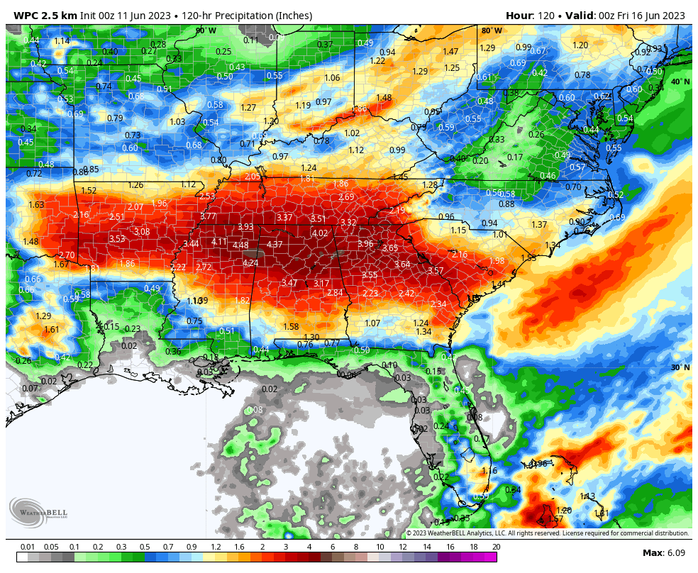
WHO LET IT GET DRY? Short term lawn and garden moisture needs are very high for sure across much of the area. Only a very limited few pockets across North and Central Alabama are in good shape, with much of the area needing 1.5-2” of rainfall according to Dr. John Christy at the University of Alabama Huntsville and his Lawn and Garden Moisture Index for Alabama. Some yellow even crept into this week’s edition of the Drought Monitor across the northern third of Alabama. The good news is that some of the best rainfall amounts forecast over the next 7-10 days are expected right here in Alabama. So we’ve got our fingers crossed for some beneficial rains for the area in the week ahead.
LOOKING BACK ON SATURDAY: The big blocking ridge that has been protecting the eastern United States from storm systems is finally beginning to break down after over a week of setting up shop. Morning readings started off in the 50s north of I-22/US-280, with 60s to the southwest. Dewpoints started out in the 50s but began to climb during the afternoon. Storms fired to the west over Mississippi during the day but they had a hard time working their way into Alabama because of all the dry air. Afternoon readings were near 90 degrees to the south and west of I-22/US-280 with idle and upper 80s to the northeast. Lows this morning will be a few degrees warmer thanks to the increased moisture and more cloud cover.
FOR YOUR SUNDAY: The basically zonal, of west to east flow across Alabama and the Deep South with throw a short wave trough our way today. This will trigger some showers and storms this morning, and an organized line of storms that will enter the state late this evening. They will likely still be severe when they reach our northwest corner, with damaging winds the main threat. In fact, the SPC has the northwestern corner of the state up around the Quad-Cities outlooked for a slight risk (their 2/5 level threat) with a marginal risk (level 1 out of 5) down to I-59. Highs today will be in the middle and upper 80s, with a few 90 degree readings down across the Black Belt of South Central Alabama. Lows tonight will be in the 60s again, and higher dewpoints will start to make it feel less comfortable.
THE WEEK AHEAD: The upcoming week looks very “trough” across the eastern half of the country. Those lower pressure heights will favor rain, clouds, and cooler than normal temperatures. Disturbances in the flow will help to trigger rounds of showers and storms. Timing those events will be difficult, but suffice to say, rain and storms will be in the forecast each day.
DAY BY DAY Tomorrow looks drier for the northern half of the state, with showers and storms over South Alabama. Tuesday through Friday look wet and stormy again with highs mostly in the 80s. Lows will be in the upper 60s to near 70F.
WHAT ABOUT THE WEEKEND: Saturday looks like it is trending dry, but Sunday looks very, very wet and stormy. We may have our eyes on some tropical mischief by that time. More in a minute. But a front moves in late Sunday and sets the stage for a pattern change during Voodoo Week Two. The front will usher any tropical system away from us if it happens. Week two looks drier and warmer for Alabama.
BEACHCAST: Daily doses of showers and storms will be in the forecast for the beautiful beaches of Alabama and Northwest Florida over the next 7-10 days. The best rain chances will be today and tomorrow, with the least in the Tuesday-Thursday time frame. Highs along the beaches will be near 90F with lows in the middle and upper 70s. Of course, it will be humid. But the daily sea breeze is refreshing for now with water temperatures still in the upper 70s. The rip current risk looks fairly low, but I wouldn’t be surprised to see that risk upgraded as we go through the week, with some fairly decent southerly winds.
Click here to see the Beach Forecast Center page.
IN THE TROPICS: The Atlantic Basin is quiet for now. I hate to even mention it, but there has been a fairly consistent signal for something to develop over the northwestern Caribbean by next Sunday the 18th. Sea surface temperatures certainly are warm enough to support the idea. It could be pulled northeastward across Cuba, South Florida, and the Bahamas early in the following week, perhaps as a minimal hurricane. Other recent runs have carried it anywhere from the Florida Panhandle to Houston to Northeast Mexico. No sense getting worked up til it shows up on the NHC new 7 day outlook.
DANCING WITH THE STATS: There were 11 states east of the Rockies with no severe weather reports in May. That is only surpassed by the 13 states back in 1972. It has been 64 years since there were no severe weather reports in Pennsylvania in May. Wow.
ADVERTISE WITH US: Deliver your message to a highly engaged audience by advertising on the AlabamaWX.com website. We have a lot of big plans for this year. Don’t miss out! We can customize a creative, flexible, and affordable package that will suit your organization’s needs. Contact me, Bill Murray, at (205) 687-0782 and let’s talk.
WEATHERBRAINS: This week, the panel will entertain Commander Doug Pearman, a METOC Officer in the U.S. Navy. Check out the show at www.WeatherBrains.com. You can also subscribe on iTunes. You can watch the show live on our new YouTube channel for the show.You will be able to see the show on the James Spann 24×7 weather channel on cable or directly over the air on the dot 2 feed.
ON THIS DATE IN 1968: A rare tornado struck mountainous, uninhabited Wallowa County OR. The short-lived tornado downed a lot of trees and would not be noteworthy except for the fact that tornadoes are so rare in Oregon. Follow my weather history tweets on Twitter. I am @wxhistorian at Twitter.com.



