


ALABAMA THIS MORNING
A calm and cool start across the state with mostly clear skies in the north and pockets of fog in valleys from Cullman to Scottsboro. Central Alabama reported fair to partly cloudy skies, while clouds were more common toward the southeast around Auburn and Dothan. Early temperatures ranged from the upper 40s in the Tennessee Valley to the lower 50s central and mid-50s to near 60 along the coast. Sunshine will take over by midmorning, leading to another warm, dry October afternoon.
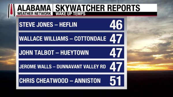
Here are some of the crisp readings reported by our Skywatcher team.
DANCING WITH THE STATS
ROCKIES SOAKED WITH NEW RAINFALL RECORDS
A wave of Pacific moisture drenched parts of the interior West, setting new daily rainfall records from Arizona to Montana. The heaviest total came from Livingston, Montana, where nearly an inch of rain fell.
Livingston, MT — 0.95 inches (old record 0.49 in 1997)
Lake Yellowstone, WY — 0.75 inches (old record 0.48 in 2021)
Phoenix, AZ — 0.70 inches (old record 0.31 in 1928)
Billings, MT — 0.51 inches (old record 0.47 in 2021)
NATIONAL OUTLOOK
EAST COAST STORM BRINGS RAIN AND COASTAL FLOODING
A coastal low tracking northward along the Atlantic seaboard is spreading moderate to heavy rain from the Carolinas to New England. Strong onshore winds and high surf are creating dangerous rip currents and areas of coastal flooding, especially in vulnerable communities along the Southeast and Mid-Atlantic coasts.
SOUTHWEST SOAKED BY TROPICAL MOISTURE
Deep Pacific moisture linked to the remnants of Tropical Cyclone Raymond continues to fuel widespread showers and thunderstorms across southern Arizona and New Mexico. Locally heavy rainfall may exceed three inches, prompting flash flood concerns in urban areas, washes, and burn scars.
HEAVY SNOW FOR THE MOUNTAIN WEST
Winter returns early to the higher elevations of the Cascades, Northern Rockies, and Sierra Nevada, where heavy snow is developing through Monday. Lower elevations will see chilly rain as a strong upper system moves inland.
QUIET ELSEWHERE WITH COOLER TEMPERATURES AHEAD
While the central and eastern U.S. stay mostly quiet outside of coastal rain, a cooling trend is expected behind the advancing fronts. More widespread rain and mountain snow are likely early this week as the Pacific system moves east into the Rockies.
NATIONAL HIGH AND LOW TEMPERATURE
Desert heat held firm in Death Valley country as Stovepipe Wells, California, soared to 99°, while autumn’s chill gripped the Pacific Northwest high country with a low of 22° near Frenchglen, Oregon.
ALABAMA WEATHER FORECAST
ALABAMA WEATHER FORECAST
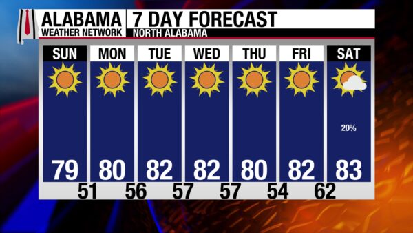
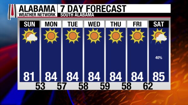
High pressure remains the dominant weather feature across the Deep South, keeping Alabama sunny, dry, and seasonably warm through much of the week. From the Tennessee Valley to the Gulf Coast, conditions stay quiet with cool mornings and mild to warm afternoons under mostly clear skies.
SUNNY AND COMFORTABLE TODAY
A crisp, fall morning gives way to a pleasant afternoon across Alabama. Highs will reach the upper 70s to near 80 in the north and low to mid 80s elsewhere. Patchy valley fog burns off early, and skies stay mostly sunny with light northerly winds around 5 to 10 mph.
CLEAR AND COOL TONIGHT
Calm winds and clear skies will make for another cool night. Lows dip into the upper 40s to lower 50s across north and central Alabama, with mid-50s along the coast. Patchy fog may form again in sheltered valleys and near rivers before sunrise.
WARMER MONDAY UNDER HIGH PRESSURE
A strong upper ridge builds overhead, bringing slightly warmer temperatures statewide. Highs climb into the low to mid-80s, with a few upper 80s possible in south Alabama. The air remains dry, and skies will stay mostly sunny.
TUESDAY THROUGH THURSDAY – DRY AND WARM
High pressure continues to dominate, keeping rain chances near zero. Afternoon highs hold in the mid-80s north and mid to upper 80s central and south. Nights remain comfortably cool in the 50s and 60s. The dry air and sunshine will further elevate fire danger across the state.
EXTENDED OUTLOOK
The warm, dry pattern looks to persist into late week as ridging holds firm. Some increase in clouds and isolated showers may return next weekend as the ridge weakens, but for now, Alabama’s October weather stays steady — mild mornings, sunny afternoons, and no significant rain in sight.
TROPICS
WAVE SHOWS SIGNS OF ORGANIZING IN THE ATLANTIC
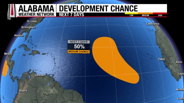
A broad tropical wave southwest of the Cabo Verde Islands is producing a large area of showers and thunderstorms. Forecasters at the National Hurricane Center note that conditions could allow gradual development over the next few days as the system tracks west-northwest at 15 to 20 mph. A tropical depression could form early to midweek, with medium chances of development—40 percent in 48 hours and 50 percent over the next seven days.
BEACH
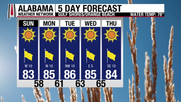
A beautiful beach day stretches from Dauphin Island to Pensacola, with sunshine, light winds, and highs in the lower 80s. Surf heights hover around a foot and water temperatures sit comfortably in the upper 70s—ideal for wading or a swim. The UV Index is high, so sunscreen is a must. Rip current risk is low, but always stay alert near piers and jetties and follow local flag warnings. No marine advisories are in effect, making it a perfect day to dig your toes in the sand and enjoy the calm Gulf waters.
WEATHER HISTORY
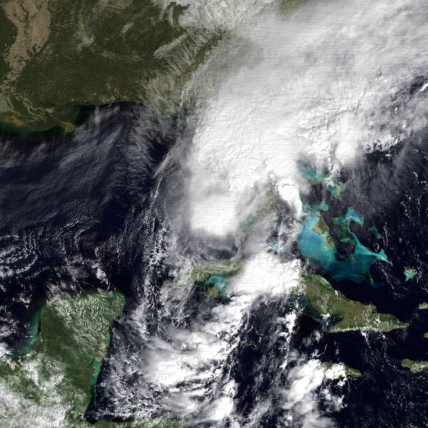
Hurricane Floyd became the only hurricane to strike the United States during the 1987 season when it crossed the Florida Keys on October 12. It briefly reached hurricane strength near Key West, with top winds around 85 mph and a minimum central pressure of 993 mb. Although Floyd quickly weakened as it moved northeast, it was notable as the first October hurricane to hit Florida in nearly two decades. Heavy rain accompanied the storm, with up to 9 inches reported across South Florida. No deaths or injuries were recorded, and total damages were estimated near half a million dollars.
WEATHERBRAINS

Episode 1030 is a Kansas City special featuring two of the city’s leading TV meteorologists, Bryan Busby and Joe Lauria. The panel dives into their experiences covering Midwest weather—from severe storm outbreaks to winter challenges—and catches up with both on their careers and lives in broadcast meteorology. Join us live at 7pm Central on our YouTube channel!



