


Shortly after 5 p.m. this afternoon, Air Force reconnaissance found a central pressure of 993 mb in Fay, a drop of 4 mb!
Infrared satellite data indicates that the cloud tops are cooling, indicating increased thunderstorm activity around the center.
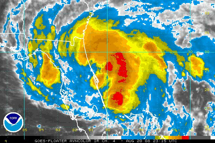
With a large intact center, continued strengthening is likely.
The plane found flight levels winds of 70 mph, which translates to a little over 60 mph. The crew estimated max surface winds of 40 knots about 60 miles southeast of the Center. This is 46 mph. The advisory was bumped up to 60 mph.
Tropical storm warnings cover much of the East Coast of Florida and Georgia, with a small section of the Georgia Coast under a tropical storm watch.
The center of Fay is about 45 miles ESE of Daytona Beach. The eye is 35 miles in diameter. It is essentially stationary..but appears to have wobbled a little west in the last few radar frames.
SPOT REPORTS AS OF 6 PM CDT…
CITY SKY/WX TMP DP RH WIND PRES REMARKS
ORMOND BEACH HVY RAIN 77 77 100 N16G35 29.62 VSB 1
DAYTONA BEACH RAIN 77 74 90 N24G39 29.57F FOG
JFK SPACE CTR RAIN 75 75 100 W28G44 29.47F FOG
TITUSVILLE HVY RAIN 77 N/A N/A W29G44 29.57F VSB 1
PATRICK AFB HVY RAIN 77 77 100 W32G41 29.58S FOG
MELBOURNE LGT RAIN 78 74 87 SW23G36 29.62S
VERO BEACH RAIN 78 76 93 SW18G30 29.71S FOG
Some Biblical rains over Florida. According to JB, as of 4 pm, EDT 24.80 inches of rain at Windover Farms and 17.35 at Melbourne NWS Office. Some unofficial reports of 25 inches! Whoever poo-poohed the idea of 25 inch 5 day rainfall amounts in a comment the other night is dining on a fine meal of crow this evening. The NHC warns there may be isolated 30 inch amounts in Florida before this is over.
Jason Kelley at WJHG in Panama City was just commenting on the fact that he thinks Fay’s dip in the Atlantic will give her just enough reintensification to survive the trip back across the Florida Peninsula. He believes it will be closer to the coast that the NHC track, perhaps as far south as Alligator Point south of Apalachicola
As James noted in his discussion, the European model takes t he storm southwestward into the Gulf before turning in Sunday night toward Mobile as a significant hurricane. That is one posisbility.



