


Hurricane Gustav is passing through the Cayman Islands tonight. The hurricane’s core is taking on a more symmetrical circular shape and it is over very warm water. There is decent outflow. The center of the hurricane is clearly visible on the Cuban weather radar at Pico San Juan.
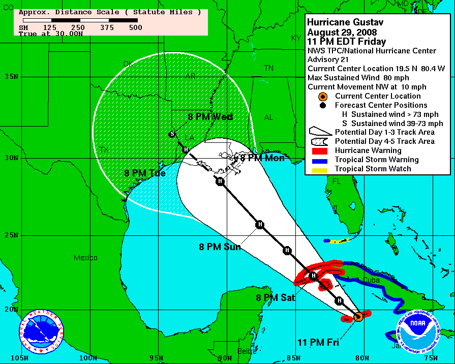
Gustav will pass about 30 miles northeast of Grand Cayman overnight. They will experience tropical storm force conditions. The twin hurricane warning flags are flying in the Caymans, as well as over western Cuba, where the hurricane will pass Saturday afternoon. The hurricane will weaken only slightly as it crosses Cuba and by late Saturday night, it will be over the southeastern Gulf of Mexico.
Top winds are 80 mph. The central pressure as measured by the NOAA recon plane was 974 millibars. The plane is already enroute back to Tampa. Gustav should intensify over the warm waters of the northwestern Caribbean under a light shear environment overnight and should be a category two hurricane by breakfast. Even as it approaches the Isle of Youth and the western tip of Cuba, it will likely still be intensifying and it could become a major hurricane before entering the Gulf.
Tropical storm force winds may briefly affect the Dry Tortugas and lower Florida Keys early Sunday morning as the wind field continues to expand. A tropical storm watch is in effect for those areas. Gustav will likely have winds in excess of 125 mph by Sunday afternoon, and it could be much stronger. By late Sunday night, it will be 300 miles SSE of New Orleans and likely be peaking in intensity. The current forecast is for the hurricane to have max winds of 130 mph at that time. They could be higher.
Tropical storm force winds will start reaching the lower reaches of Plaquemines Parish, Louisiana before daybreak Monday. By that time, it will be 300 miles southeast of New Iberia. Tropical storm force winds will reach New Orleans by noon and be overspreading the parishes of southern Louisiana. Strong tropical storm force winds (greater than 50 mph) will be overspreading the parishes during the afternoon. Hurricane force winds will arrive by nightfall. The center of the hurricane should make landfall around daybreak south of New Iberia and continue northwestward, passing north of Lake Charles and then into Texas by Wednesday morning.
There is still great uncertainty in this forecast at this time. People all along the Gulf Coast from Corpus Christi, Texas to Pensacola, Florida have to remain on guard but the primary threat appears to be shifting to western and central Louisiana. Hopefully this bodes well for New Orleans.



