


Brian will be along within the next hour or two with his discussion and Weather Xtreme video…
Hopes for a pre-Christmas snow in Alabama are fading fast as the next mid-latitude cyclone is forecast by most global models to be much farther north that recent ones, with the surface low running a path from Albuquerque to Chicago. With the genisis of the event now with 84 hours, confidence can build in model solutions.
SPC has outlooked a risk of severe weather on day 4 (Wednesday) just west of Alabama:
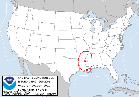
There could be a few strong to severe storms around here Wednesday night or Thursday; it all depends on the timing and the amount of instability available, which is somewhat marginal.
Christmas Day will be much colder, but generally dry in the wake of the passing storm system.
So, for now, the idea of a significant chance of snow is off the table. But, expect more surprises in coming days and weeks in this challenging pattern. Global models have had a hard time with every system during the past four weeks in this El Nino cycle with a strongly negative AO and NAO. Model output statistics have been way too warm, and storm placement and intensity have been way off. It was interesting to watch the media and the NWS to play catch up with the historic snow storm that is still raging this morning over the Northeast U.S.
And, for the haters, trolls, and know-it-alls, remember, what we share here are long range ideas, NOT forecasts. Nobody ever takes the time to read the statements made here last week. Here is the exact quote from the Thursday afternoon discussion (December 17)…
“LOOKING FOR A SLEIGH RIDE: Not much change in our thinking next week. A major pre-Christmas storm is likely, and it is way too early to even think about who gets rain and who gets snow. There is no skill in identifying a rain-snow line six days in advance. But, confidence is high the system will develop as forecast. Watch the Weather Xtreme video; you will see the 12Z GFS has trended northward with the surface low, keeping us with mostly rain, but every run will look different. Forget the individual runs, use the ensemble approach.
We will have rain or snow, or perhaps rain changing to snow, in the Wednesday-Thursday time frame next week. Where the snow falls, it could be heavy and travel could be impacted, so if you are headed “home for the holidays”, keep in touch with the latest weather developments. We should have a pretty good idea on an initial rain-snow line Sunday.”
The pre-Christmas storm indeed will develop, and this is Sunday, so now we can forecast the rain-snow line well north of Alabama. There will be heavy snow north of the surface low track, where travel will be impacted in a big way. And, the risk of heavy rain or strong storms down this way don’t make for a fun road trip.
When we say “there is no skill in identifying a rain-snow line six days in advance”, we mean it. The purpose of this blog is to throw out the barrier between the public and our thought process in the weather office. Our official forecast is over on the seven day planner page on abc3340.com… with never goes beyond seven days. Most everybody has appreciated the time we take to put this content together, and we have a very large audience, one we like to call the blog family. The core of our readers know what we do and how it works. For the small percentage of trolls, haters, and know-it-alls, they use our long range thoughts to drop their bombs. I don’t mind the personal attacks on me, but if you saw the filth (profanity and personal attacks on others) that never make it, you would be shocked. But, God loves the trolls and I hope they find some peace they seriously need here at Christmas.
This active pattern goes nowhere in coming weeks, and there will be more storms and rumors of storms. Stay tuned… and have a nice Sunday!



