


Severe weather threat is increasing west of the state.
The SPC has just issued a new tornado watch for much of northern Mississippi, western Tennessee, and eastern Arkansas. This watch is in effect until 8PM this evening and includes Memphis, Pine Bluff, Oxford, and the entire Delta of Mississippi
We are expecting additional watches to be extended eastward later this evening as the severe weather threat shifts east. Now is the time to plan ahead and make sure you have a reliable source for severe weather alerts, especially since the worst of the weather will be moving through Alabama during the overnight hours.
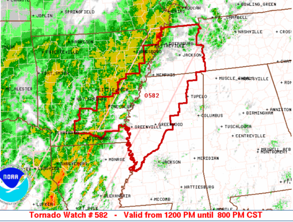
THE NWS STORM PREDICTION CENTER HAS ISSUED A
* TORNADO WATCH FOR PORTIONS OF
EASTERN ARKANSAS
WESTERN MISSISSIPPI
WESTERN TENNESSEE
* EFFECTIVE THIS SATURDAY AFTERNOON AND EVENING FROM NOON UNTIL
800 PM CST.
* PRIMARY THREATS INCLUDE…
SEVERAL INTENSE TORNADOES POSSIBLE
SEVERAL DAMAGING WIND GUSTS TO 70 MPH LIKELY
THE TORNADO WATCH AREA IS APPROXIMATELY ALONG AND 65 STATUTE
MILES EAST AND WEST OF A LINE FROM 10 MILES WEST SOUTHWEST OF
GREENVILLE MISSISSIPPI TO 50 MILES NORTHEAST OF DYERSBURG
TENNESSEE. FOR A COMPLETE DEPICTION OF THE WATCH SEE THE
ASSOCIATED WATCH OUTLINE UPDATE (WOUS64 KWNS WOU2).
PRECAUTIONARY/PREPAREDNESS ACTIONS…
REMEMBER…A TORNADO WATCH MEANS CONDITIONS ARE FAVORABLE FOR
TORNADOES AND SEVERE THUNDERSTORMS IN AND CLOSE TO THE WATCH
AREA. PERSONS IN THESE AREAS SHOULD BE ON THE LOOKOUT FOR
THREATENING WEATHER CONDITIONS AND LISTEN FOR LATER STATEMENTS
AND POSSIBLE WARNINGS.



