


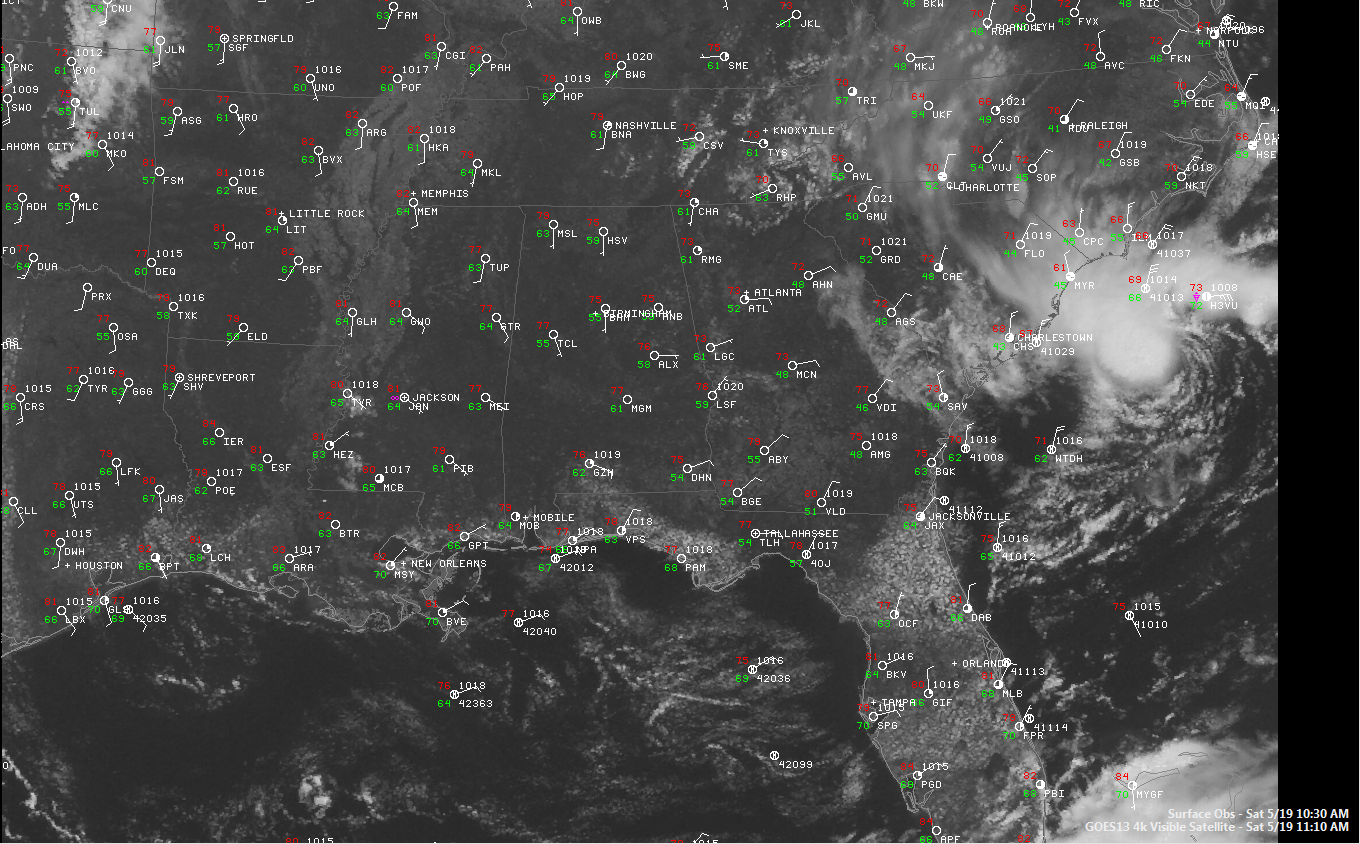
It’s a beautiful day across Central Alabama on this Doo Dah Day 2012.
Temperatures are warming nicely through the 70s heading for afternoon highs in the upper 80s. There is not a cloud in the sky on visible satellite photos. A few cumulus clouds will develop this afternoon, and there is a small chance (less than 10%) that you could see a shower or storm at your event. Humidities are not too bad, but remember the sunscreen.
Looking to the east, your eye is drawn to that tight circle of clouds off the Carolina coast. It is a low pressure system that has really gotten better organized this morning. The NHC has upped the chance that it could become a tropical depression or tropical storm to 50% over the next 48 hours as it moves slowly southwestward.
The buoy at Frying Pan Shoals south of Wilmington has been consistently reporting sustained winds of 35 mph with gusts to near 40 mph. Waves running about 8 feet.
This or another low is expected to move northward over the next day or and eventually make a move toward New England, where they are expecting rain by midweek.
Here is the text of the Special Tropical Weather Outlook just out from the NHC.
000
ABNT20 KNHC 191556
TWOAT
SPECIAL TROPICAL WEATHER OUTLOOK
NWS NATIONAL HURRICANE CENTER MIAMI FL
1155 AM EDT SAT MAY 19 2012
FOR THE NORTH ATLANTIC…CARIBBEAN SEA AND THE GULF OF MEXICO…
SATELLITE AND RADAR IMAGERY INDICATE THAT THE AREA OF LOW PRESSURE
LOCATED ABOUT 120 MILES SOUTHEAST OF MYRTLE BEACH SOUTH CAROLINA
HAS BEGUN TO ACQUIRE MORE TROPICAL CHARACTERISTICS…AS SHOWERS AND
THUNDERSTORMS HAVE INCREASED NEAR THE CIRCULATION CENTER.
ADDITIONAL DEVELOPMENT OF THIS SYSTEM IS POSSIBLE…AND IT COULD
BECOME A TROPICAL DEPRESSION OR TROPICAL STORM AS IT MOVES SLOWLY
SOUTHWARD OR WESTWARD OVER THE NEXT DAY OR SO. THIS SYSTEM HAS A
MEDIUM CHANCE…50 PERCENT…OF BECOMING A TROPICAL CYCLONE DURING
THE NEXT 48 HOURS. FOR ADDITIONAL INFORMATION ON THIS SYSTEM…
PLEASE SEE PRODUCTS FROM YOUR LOCAL NATIONAL WEATHER SERVICE
OFFICE. ADDITIONAL SPECIAL TROPICAL WEATHER OUTLOOKS WILL BE
ISSUED ON THIS SYSTEM LATER TODAY OR SUNDAY…IF NECESSARY.
ELSEWHERE…TROPICAL CYCLONE FORMATION IS NOT EXPECTED DURING THE
NEXT 48 HOURS.
&&
ADDITIONAL INFORMATION ON THIS SYSTEM CAN BE FOUND IN HIGH SEAS
FORECASTS ISSUED BY THE NATIONAL WEATHER SERVICE…UNDER AWIPS
HEADER NFDHSFAT1 AND WMO HEADER FZNT01 KWBC.
$$
FORECASTER BRENNAN/CANGIALOSI
BTW: did you hear that NOAA has appointed a new Director of the National Hurricane Center to replace Bill Read, who is retiring? It is Dr. Rick Knabb, who has been the Tropical Expert at The Weather Channel for the past two years.



