


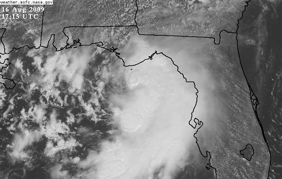
Tropical Storm Caludette was named at 1115 am CDT, due to winds of 40 mph detected by the Tallahassee Doppler radar. Aircraft reconnaisance found flight-level wind of 63 mph. The satellite presentation of Claudette, while not symmetrical and intense like a hurricane, has improved this morning, as one can see large intense thunderstorms around the storm, that may help lower its pressure and increase its wind some more before it makes landfall near Panama City, FL tonight.
NHC predicts it will have maximum sustained winds of 65 mph as it comes ashore, so only minor wind damage (a few trees and signs down, power outages) is anticipated. But, not a good night to be at the beach. Storm tides of 3 to 5 feet above normal are expected, and that could get the water up close to some of the condos on the east end of the Florida panhandle, but unless more strengthening occurs, most condos and houses should be OK. A Tropical Storm Warning is in effect for Pensacola, Destin, Fort Walton, Panama City Beach, and Appalachicola.
NHC predicts that Claudette will continue moving NW rather quickly after landfall, reaching Greenville, AL by 7 am Monday, still at tropical storm strength (sustained winds 40 mph). The storm should then weaken as it moves through west Alabama tomorrow.
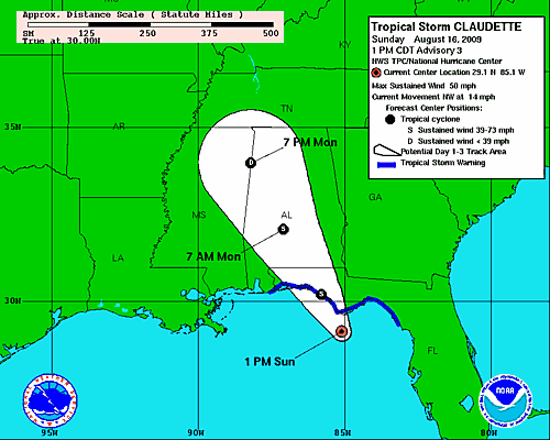
Tornadoes are not expected to be a big problem, since the wind field around Claudette is not that strong. With the storm still at Tropical Storm strength tomorrow morning in south Alabama, expect very windy conditions overnight from Panama City and Bonifay up through Geneva, Enterprise, Opp, Andalusia, and Luverne. Some tree and power line damage is possible there.
Rainfall is difficult. The computer models don’t seem to be doing a great job of initializing Claudette, so their forecasts have to be suspect. NHC’s forecast of 3-5″ of rain over much of NW Florida and south Alabama looks accurate, with a few spots getting more. Farther north (BHM, TCL, ANB), Claudette will bring in lots of moisture, and may still have a little circulation all the way up to Tuscaloosa. So, we could see some heavy rain at times tomorrow in Birmingham, with a few locations getting over 2″.



