


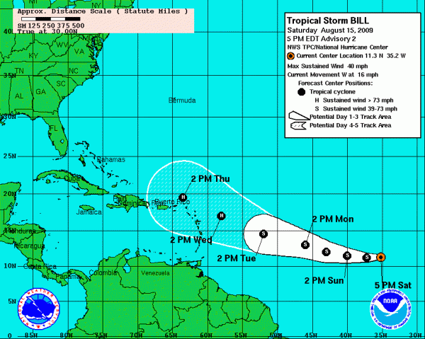
Here is the official NHC track for Bill. It carries it to a point just north of the U.S. Virgin Islands by Thursday. The forecast uncertainty area shows that the center could be well north of the islands to anywhere in the Leewards. The Leewards are the northern half of the Lesser Antilles, that chain of islands strung across the entrance to the eastern Caribbean.
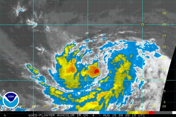
INTENSITY FORECAST
The forecast is for slow intensification and Bill is expected to become a hurricane by Wednesday and have top winds of 90 knots (105 mph) as it threatens the islands on Thursday. Interesting to note that HWRF has Bill as a major category four hurricane with a central pressure of 920 mb and winds of 135 mph. It does keep the storm center north of the islands, which would be very good news.
Here is the complete text of the official advisory…
000
WTNT33 KNHC 152033
TCPAT3
BULLETIN
TROPICAL STORM BILL ADVISORY NUMBER 2
NWS TPC/NATIONAL HURRICANE CENTER MIAMI FL AL032009
500 PM AST SAT AUG 15 2009
…TROPICAL STORM BILL…THE SECOND TROPICAL STORM OF THE SEASON
FORMS IN THE FAR EASTERN ATLANTIC…
SATELLITE IMAGES INDICATE THAT TROPICAL DEPRESSION TWO HAS
STRENGTHENED AND HAS BECOME TROPICAL STORM BILL..THE SECOND NAME
CYCLONE OF THE SEASON. AT 500 PM AST…2100 UTC…THE CENTER OF
THE TROPICAL STORM WAS LOCATED NEAR LATITUDE 11.3 NORTH…LONGITUDE
35.2 WEST OR ABOUT 820 MILES…1320 KM…WEST-SOUTHWEST OF THE CAPE
VERDE ISLANDS.
BILL IS MOVING TOWARD THE WEST NEAR 16 MPH…26 KM/HR. A GRADUAL
TURN TO THE WEST-NORTHWEST IS EXPECTED DURING THE NEXT FEW DAYS.
MAXIMUM SUSTAINED WINDS HAVE INCREASED TO NEAR 40 MPH…65
KM/HR…WITH HIGHER GUSTS. SOME STRENGTHENING IS FORECAST DURING
THE NEXT 24 HOURS.
TROPICAL STORM FORCE WINDS EXTEND OUTWARD UP TO 30 MILES…45 KM
FROM THE CENTER.
ESTIMATED MINIMUM CENTRAL PRESSURE IS 1004 MB…29.65 INCHES.
…SUMMARY OF 500 PM AST INFORMATION…
LOCATION…11.3N 35.2W
MAXIMUM SUSTAINED WINDS…40 MPH
PRESENT MOVEMENT…WEST OR 265 DEGREES AT 16 MPH
MINIMUM CENTRAL PRESSURE…1004 MB
THE NEXT ADVISORY WILL BE ISSUED BY THE NATIONAL HURRICANE CENTER AT
1100 PM AST.
$$
FORECASTER AVILA



