


High clouds have increased most of Alabama this afternoon. The only exception is over the Northwest part of the state, where skies have remained sunny. Light radar echoes are showing up over South Alabama and the Florida Panhandle, but most of this is not reaching the ground.
Temperatures were near 50 degrees in the I-20 corridor. Readings are colder over the Northwest, despite the brighter sunshine. To the north, we find the upper low that caused the Christmas Blizzard still rotating around the Great Lakes. It is moving east this afternoon, and a lobe of energy rotating around it push a reinforcing shot of colder air southeastward out of Missouri tonight.
Readings tonight across the area will drop into the middle 20s on average, actually on the low side of the middle 20s, with some spots getting into the lower 20s. A chilly northwest wind will make it feel even colder overnight. Monday will be really cold, with highs struggling to get out of the 30s in many locations. Monday night readings will be in the middle 20s again. Tuesday will feature partly cloudy skies with a high near 50 degrees on average.
WINTRY PRECIP IN THE FORECAST?
Lots of attention is paid to our weather forecasts when the rare possibility of winter weather arises in Central Alabama.
There is still a chance that we will deal with some forms of wintry precipitation in Alabama over the next seven days as a really cold airmass continues to settle into the eastern U.S. Combining that with an active southern branch of the jet stream makes for some interesting forecast issues.
Here are my thoughts after the morning model run…
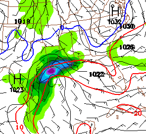
Clouds will start to thicken Tuesday night as a trough moves out of the Southwest U.S. and a low forms along the Texas coast. Enough moisture could get in here during the pre-dawn and early morning hours on Wednesday to produce sleet across Central Alabama. The precipitation should be light enough to preclude real problems. But it is something to be watched.
Here is the depiction from the GFS for 6 a.m. CST Wednesday morning.
FREEZING RAIN THURSDAY MORNING?
The low will move eastward, changing the wintry mix over to all rain during the day Wednesday. Rain will be likely through Wednesday night, with average amounts around one inch. There is some concern that the rain could change over to freezing rain for a brief time Thursday morning, but for now, we will leave that out of the forecast. Thursday should be mostly cloudy as the rain departs.
SNOW FOR NEW YEAR’S?
The event won’t be over though, as the main trough doesn’t swing through until Thursday night. There are still signs it could produce a snow event across parts of North and Central Alabama Thursday night into Friday morning. A dusting to an inch or two or snow is a possibility.
Here is the morning GFS run for midnight Thursday night…
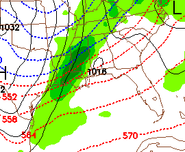
The blue line signifies the 540 meter 1000-500 millibar thickness line, a key indicator for the changeover to snow. Notice the precipitation spreading across the northern half of the state as a strong disturbance passes, changing over to snow in Northwest Alabama during the evening, with the changeover spreading southeastward during the night.
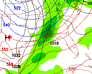
The look at 6 a.m. shows snow down through the I-20 corridor, with some fairly significant snows possible.
While it is just a chance at this point, it is something that will be interesting to watch. With all kinds of New Years Eve festivities planned across the area, everyone will want to pay attention to the latest forecasts over the coming days.
Bitter cold follows for the weekend. Highs on Saturday just might not get above freezing across parts of Central and North Alabama. The MOS is now outputting 21 for Saturday morning and 22 for Sunday morning. I think it will be considerably colder than that.



