


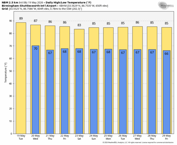
SUMMER PATTERN SETS IN: The calendar says May, but the weather will be more like June for the rest of the week and into the holiday weekend. Highs will stay generally in the 85-90 degree range, humidity levels will be higher, and we will have the risk of a passing shower or storm daily.
An upper ridge with warm air aloft will hold today across Alabama, so afternoon showers/storms should be very isolated. But, as the ridge weakens and a surface front approaches, we expect a slow increase in rain chances tomorrow through Friday. Understand the showers and thunderstorms will be scattered and random; no way of knowing when and where they pop up in advance. Most of them will come from roughly 2:00 until 10:00 p.m. when the air is most unstable.
Not much change for the holiday weekend. No wash-out, but be ready to dodge a shower or thunderstorm from time to time, especially during the afternoon and evening hours. Highs Saturday through Monday will be generally in the mid to upper 80s.
REST OF NEXT WEEK: After Memorial Day global models suggest we will have the chance of scattered to numerous showers and storms through the week as colder air aloft makes the air more unstable… See the video briefing for maps, graphics, and more details.
ON THIS DATE IN 1973: Three tornadoes tore through North Alabama… an F2 in Madison County near Hazel Green, an F2 in Jackson and Dekalb counties which affected South Scottsboro, Section, and Powell, and an F4 which affected Fort Payne and Lookout Mountain in DeKalb County. On the ground for 5.4 miles, the Fort Payne tornado caused 19 injuries. At least 37 buildings were destroyed just north of downtown Fort Payne and 117 buildings were damaged. 150 people were attending the “Little Miss Maid of Cotton” contest at a school gymnasium. Attendees took cover against the walls of the gym just before the tornado struck. Despite damage to the gymnasium, there were no injuries at the school.
Look for the next video briefing here by 3:00 this afternoon… enjoy the day!



