


An all new edition of the ABC 33/40 Weather Xtreme video is available in the player on the right sidebar of the blog. You can subscribe to the Weather Xtreme video on iTunes by clicking here.
RADAR CHECK: We have a few sprinkles on radar this morning across Alabama… this is the far southern end of the storm system that brought blizzard conditions to parts of the Dakotas and Minnesota yesterday and last night. The low levels are pretty dry, and the activity on radar is fading fast as I write this just before sunrise.
The day ahead will feature a mix of sun and clouds, with a high between 77 and 80 degrees this afternoon.
TOMORROW/THURSDAY: For Alabama, these two days will be warm, and generally dry. Just a slight risk of a shower, afternoon highs around 80 degrees with the sun/cloud mix continuing.
While we have warm and quiet weather, things get active across the Southern Plains; severe weather is possible both days. The most active period should come Thursday; SPC has defined the standard “slight risk” of severe weather from Northeast Texas to Central Indiana…
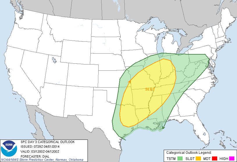
We note the “slight risk” does extend into the northwest corner of Alabama late Thursday night.
Looks like all modes of severe weather, including tornadoes, will be possible Thursday afternoon and Thursday night over much of Arkansas, extending into West Tennessee and Northwest Mississippi as a deepening surface low moves northeast through Missouri. Then, late Thursday night, this activity should roll over into a long squall line, moving into Alabama sometime during the pre-dawn hours Friday (in the 1 a.m. to 4 a.m. time frame). The storms could be severe as they move through the Shoals with potential for strong, perhaps damaging winds. But then, the thunderstorms should weaken as they move southeast, and the severe weather threat for North-Central Alabama during the day Friday remains low as the primary dynamic support moves well to the north, and wind fields weaken during the day.
FRIDAY: The air will be unstable Friday, however, with surface based CAPE values expected to exceed 2,000 j/kg over Southwest Alabama, and over 1,500 j/kg over the north-central counties. But, with the weak wind fields and low shear values, it just doesn’t look like we will have a problem with severe weather Friday. But, now doubt we will have a few showers and thunderstorms to deal with Friday with a cloudy sky and a high in the mid to upper 70s.
THE ALABAMA WEEKEND: Saturday will be dry and cooler with a high around 70 degrees along with a partly sunny sky. Rain could linger over the far southern part of Alabama around Mobile and Dothan as the surface front will stall out somewhere near U.S. 84.
We are finally getting better model agreement on what happens later in the weekend. A wave of low pressure will form along the old front in the Northwest Gulf of Mexico, and will spread a soaking rain into Alabama Sunday night and Monday. The European model (the ECMWF) suggests the rain could begin Sunday afternoon, while the GFS holds the rain off until Sunday night. We will go ahead and introduce the chance of rain during the afternoon hours Sunday, with the rain becoming widespread, and possibly heavy at times Sunday night into Monday.
There are differences in the placement of the surface low; the GFS has the low near Demopolis early Monday morning, while the ECMWF has it closer to Nashville. The position of the low will determine if we will have a strong thunderstorm threat; just too early to call at this point.
LATER NEXT WEEK: Global models are signaling that the upper trough will become established again over the eastern third of the nation, and there is increasing evidence we will have another freeze/frost threat toward the end of next week. Growers beware… it is still too early to plant anything that can be harmed by frost or a freeze. See the Weather Xtreme video for the maps, graphics, and details.
AT THE BEACH: Partly sunny mild days and fair nights along the coast from Panama City to Gulf Shores through Thursday with potential for late night and morning fog; any showers should be very isolated. Showers and storms return Friday into the weekend. Highs will be in the 60s along the immediate coast, with 70s just a few miles inland. Rain will become heavy along the coast Sunday night and Monday.
The sea water temperature at the Dauphin Island Sea Lab this morning is 63 degrees.
WEATHER RADIO HELP? Need help with your weather radio? We will be at Academy Sports in Trussville tomorrow from 3:30 until 6:30 p.m… come see us…
WEATHER BRAINS: Don’t forget you can listen to our weekly 90 minute netcast anytime on the web, or on iTunes. This is the show all about weather featuring many familiar voices, including our meteorologists here at ABC 33/40. We will produce this week’s show tomorrow night at 8:30p CT.
CONNECT: You can find me on all of the major social networks…
Facebook
Twitter
Google Plus
Instagram
I have a weather program this morning for the pre-school at Gardendale’s First Baptist Church… look for the next Weather Xtreme video here by 4:00 or so this afternoon. Enjoy the day….



