


Daily Weather Briefing
Saturday, March 21, 2026
ALABAMA THIS MORNING
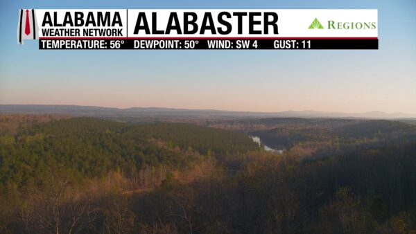
Skies are mostly clear this morning, with temperatures sitting in the low to mid 50s in south/south-central Alabama and the upper 50s to around 60 degrees in the north. The Alabaster Regions Skycam captures a calm, beautiful morning.
ALABAMA 7 DAY FORECAST
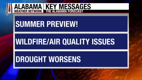
The weather continues its warm and mostly dry pattern through next week as upper-level ridging settles over the southwest U.S. Today will be warm, with a verY low chance of showers in north Alabama. Tomorrow will be warm and dry, then a cold front will move through the state Monday with very few impacts. The only impact is slightly cooler temperatures. The warmth continues into next week, with a low chance for showers and thunderstorms Tuesday into Wednesday. The pattern will be warm and dry past then.
WARM SATURDAY
Today, highs will sit in the lower to mid 80s statewide. Clouds will be few and far between. There is a low chance for a shower or thunderstorm in the north this afternoon, but no severe weather is expected. Get outside and enjoy spring today!
COOL-ISH NIGHT
As highs increase this week, so do low temperatures. Clouds will be sparse and lows will fall to the mid 50s to lower 60s across Alabama.
INCREASED WARMTH SUNDAY
As the ride builds, temperatures increase. Highs will hit the mid 80s across the state on Sunday. Skies will remain clear.
WEAK COLD FRONT MONDAY
A weak, dry cold front will move through the state Monday into Tuesday. It will bring very little impact, just slightly cooler temperatures for the north. Highs will range from the low to upper 70s in the north to the low 70s centrally to low 80s in the south.
SLIGHTLY COOLER TUESDAY
Highs in the 70s will spread further south as the “cooler” air settles in for the day. South Alabama will see the low 80s. A shower or two may fall in the north.
WARMING TREND WEDNESDAY AND THURSDAY
Wednesday begins a “warming trend,” and highs will reach the mid to upper 80s in the northern half of the state and the lower 80s in the southern half.
Highs will quickly rebound into the mid 80s statewide Thursday.
SHIFT FRIDAY
Another shift toward cooler temperatures occurs Friday, with highs hitting the upper 60s and upper 70s in north/north-central Alabama. The south/south-central portion will see highs in the lower to mis 80s.
SLIGHTLY IMPROVED CONDITIONS WON’T LAST LONG
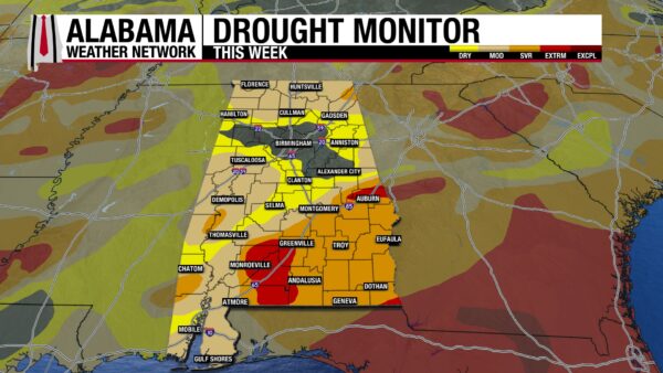
After last week’s rains, we’ve seen a slight improvement in drought conditions across the state. They are not expected to last long, however, as we are settling into an unusual dry pattern for this time of year. For now, though, 11.49% of the state is drought free, which the entire percentage is in north central Alabama. The Abnormally Dry and Moderate Drought categories have seen an around 6% decrease in percentage each of state covered. The Severe Drought category has seen much less than a one percent decrease in coverage. The Extreme Drought category remains consistent, sitting at 5.19%.
GOOD BEACH CONDITIONS
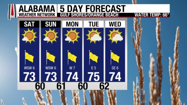
With a low rip current risk, a surf height of one foot, and a water temperature in the mid 60s, the waters are nice for a good beach weekend. The high will hit the lower 70s, with southwest wind at 5 to 10 mph, and a very high UV Index due to sunny skies.
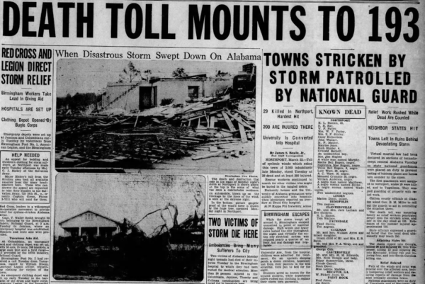
TODAY IN WEATHER HISTORY
March 21, 1932 – Deep South Tornado Outbreak
On March 21, 1932, one of the most violent tornado outbreaks in United States history struck the South and Midwest, producing destructive storms from Mississippi to South Carolina and northward into Indiana. Severe thunderstorms developed during the afternoon and spawned a wave of tornadoes that moved across Alabama in two primary waves from mid-afternoon through early evening. In total, 36 tornadoes during the outbreak were rated F2 or stronger, including ten violent F4 tornadoes, with wind speeds estimated between 207 and 260 mph. Across Alabama, at least 268 people were killed and 1,874 were injured, making it the worst weather disaster in the state’s history. The first tornadoes touched down around 3:30 p.m. in west-central Alabama near Demopolis, Linden, and Faunsdale, where 36 people were killed, 136 were injured, and approximately 180 homes were destroyed. About thirty minutes later, one of the most destructive tornadoes struck the Tuscaloosa and Northport areas. Witnesses described the funnel as resembling a giant white ice cream cone as it crossed the Black Warrior River and tore through residential and commercial areas. The storm destroyed around 100 homes, damaged roughly 300 more, killed 37 people, and injured about 200 others. A clock in the demolished Tuscaloosa Country Club stopped at 4:01 p.m., marking the moment of the storm’s passage. Hospitals quickly filled with injured residents, forcing the University of Alabama gymnasium to be converted into an emergency hospital. Reports from the scene described the destruction as resembling the aftermath of a bombing. Meanwhile, a catastrophic F4 tornado touched down near Marion in Perry County around 4:30 p.m. and carved a 60-mile path across Bibb, Chilton, Shelby, and Coosa counties. Twenty-one people were killed in Perry County alone, including seven members of one family. Entire communities such as the Cox settlement near Lawley were leveled, and additional fatalities occurred near Jemison and Union Grove in Chilton County. In total, this single tornado killed 49 people and injured about 150 as homes were swept away and large sections of the countryside were flattened. The destruction continued as additional violent tornadoes struck other parts of the state. One F4 tornado devastated Sylacauga and the surrounding areas of Talladega County, killing 41 people, injuring at least 325, and damaging or destroying approximately 600 homes along its 25-mile path. Another F4 struck southern Shelby and western Talladega counties near Columbiana, killing 14 people and injuring 75 while destroying at least 40 homes and damaging about 200 more. In east-central Alabama, another F4 tornado moved through Talladega, Clay, and Randolph counties, destroying at least 75 homes, damaging buildings on more than 110 farms, killing 13 people, and injuring 160 others along a 45-mile path. As evening approached, tornado activity shifted toward northern Alabama and the Tennessee Valley. A powerful F4 tornado tracked across Morgan, Madison, and Jackson counties before continuing into Tennessee along a path roughly 75 miles long and about 400 yards wide. The storm killed dozens of people and injured hundreds as it destroyed homes and farm buildings across the region. Additional tornadoes struck communities across Winston, Cullman, Morgan, Lawrence, Hale, Perry, and Marengo counties, leaving trails of destroyed homes, barns, and tenant houses. The toll across Alabama was staggering. Entire communities were flattened, roads were blocked by fallen trees, and hospitals and emergency workers struggled to care for the wounded through the night using lanterns and flashlights. Doctors and nurses from Birmingham and Montgomery traveled to the hardest-hit areas to assist with rescue and medical care. In Chilton County alone, 58 people were killed, and hundreds more were injured as communities near Jemison and Union Grove were devastated. Governor B. M. Miller issued a statewide call for assistance and spent days traveling across the damaged areas offering aid and encouragement to survivors. The outbreak ultimately produced hundreds of fatalities across the region and widespread destruction that was described at the time as almost beyond estimate. Alabama bore the brunt of the disaster, with tornadoes striking communities from west-central Alabama to the Tennessee Valley over the course of only a few hours. The event remains one of the most violent tornado outbreaks on record and stands as the deadliest weather disaster in Alabama history.
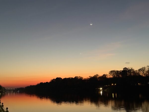
IMAGE OF THE DAY
Skywatcher Vanessa Sanchez sent in this photo over the Black Warrior River last night.



