



A severe thunderstorm watch has been issued for the southern 2/3 of Alabama today. The watch does not include Birmingham, Tuscaloosa or Anniston, but includes all counties south of the Interstate 20 corridor. Severe storms have developed this morning across west and central Alabama. These storms are the first in what could be several rounds of strong and severe storms today. Storms will continue to push south through the watch through out the rest of the afternoon. The main severe weather threat today will be the chance for damaging straight-line winds. Hail, intense rain and frequent lightning are possible as well.
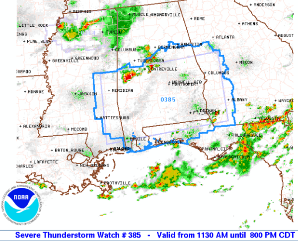
THE NATIONAL WEATHER SERVICE HAS ISSUED SEVERE THUNDERSTORM WATCH
385 IN EFFECT UNTIL 8 PM CDT THIS EVENING FOR THE FOLLOWING AREAS
IN ALABAMA THIS WATCH INCLUDES 25 COUNTIES
IN CENTRAL ALABAMA
AUTAUGA BIBB CHILTON
COOSA DALLAS ELMORE
LOWNDES MONTGOMERY PERRY
SHELBY TALLADEGA
IN EAST CENTRAL ALABAMA
CHAMBERS CLAY LEE
MACON RANDOLPH RUSSELL
TALLAPOOSA
IN SOUTHEAST ALABAMA
BARBOUR BULLOCK PIKE
IN WEST CENTRAL ALABAMA
GREENE HALE MARENGO
SUMTER
THIS INCLUDES THE CITIES OF…ALABASTER…ALEXANDER CITY…
ASHLAND…AUBURN…BRENT…CENTREVILLE…CLANTON…COLUMBIANA…
DEMOPOLIS…EUFAULA…EUTAW…FORT DEPOSIT…GREENSBORO…
LANETT…LINDEN…LINEVILLE…LIVINGSTON…LOWNDESBORO…MARION…
MILLBROOK…MONTGOMERY…MOUNDVILLE…OPELIKA…PELHAM…
PHENIX CITY…PRATTVILLE…ROANOKE…ROCKFORD…SELMA…
SYLACAUGA…TALLADEGA…TROY…TUSKEGEE…UNION SPRINGS…
UNIONTOWN…VALLEY…WETUMPKA AND YORK.
WWWW



