


An all new edition of the ABC 33/40 Weather Xtreme video is available in the player below. You can subscribe to the Weather Xtreme video on iTunes by clicking here.
NOTE: We have turned comments back on… hopefully traffic has slowed enough for us to leave this on for the rest of the event. We were hammered with an incredible amount of traffic this morning!
TO THE WEST: Snow still falling heavily on the back side of the cold core upper low over Mississippi. Watch the Weather Xtreme video, and you will see that the 0C degree isotherm at 850 mb (freezing level at 5,000 feet or so off the ground), should stay generally along and south of I-59 this afternoon. That is one of the seasons I shifted my snow band south earlier this morning, and I still think that is the correct idea. Watch the Weather Xtreme video for the upper air maps that tell the story.
I see the NWS in Memphis has cancelled the winter weather advisory for their counties in North Mississippi; everything there is rain simply because the cold core is too far to the south. Rain will continue over Northwest Alabama this afternoon, but I just don’t see the dynamic cooling there to change the rain to snow, until maybe the very end of the event.
BOTTOM LINE: The best chance of getting some snow accumulation this evening is along and south of I-59, and along and north of U.S. 80, or the basic area between Birmingham and Montgomery. With the heaviest precipitation to the north, I think we can forecast the potential of 1 to 2 inches of snow in grassy areas across Central Alabama… remember, roads should be simply wet and major travel issues are not expected. Most of the snow in this region should come between 4:00 p.m. and 10:00 p.m. All of the precipitation will be gone by midnight. See the map below:
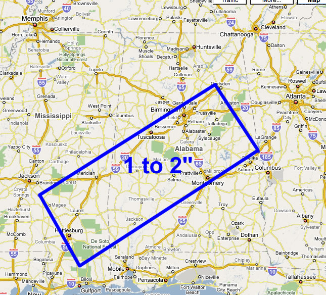
I know this doesn’t agree with all of the forecasts out there, but based on the position of the cold core aloft, I think this is the correct solution. But, like I have said many times this week, skill in forecasting these kind of events is not the best. It might change again as we go through the afternoon and see radar trends.
TOMORROW AND SATURDAY: Sunshine returns; the high tomorrow will be in the upper 40s, followed by mid 50s Saturday. We will be below freezing both tomorrow and Saturday morning. As Tim points out below, any liquid on roads could be ice at daybreak tomorrow.
SUNDAY AND NEXT WEEK: Moisture levels increase. I think Sunday will be dry, but a few showers could show up Monday and Tuesday in scattered spots. Showers are more likely Wednesday with a surface boundary drifting down into North Alabama.
See the Weather Xtreme video for voodoo land coverage.
WEATHER BRAINS: Don’t forget you can listen to our weekly 30 minute netcast anytime on the web, or on iTunes. This is the show all about weather featuring many familiar voices, including our meteorologists here at ABC 33/40. You can even listen here on the blog; look for the player on the top left.
TWITTER: Don’t forget, you can follow our news and weather updates from ABC 33/40 on Twitter here. And, my personal Twitter feed is here if you want to keep up with my adventures in life. Twitter is a short messaging service you can receive via the web, cell phone, or IM.
I had a great time seeing the kids at Bessemer Academy this morning; they will be on the KIDCAM tomorrow at 5:00 on ABC 33/40 News. Stay tuned for updates on the snow event through the night… the next Weather Xtreme video will be posted by 7:00 a.m. tomorrow…



