


An all new edition of the ABC 33/40 Weather Xtreme video is available in the player on the right sidebar of the blog. You can subscribe to the Weather Xtreme video on iTunes by clicking here.
COMPLEX FORECAST: This remains a forecast packed with weather changes for Alabama over the next seven days. Spring-like warmth, Arctic cold, rain, strong storms, some freezing rain, and maybe even a snow flake between now and the middle of next week. Take a little time to watch the Weather Xtreme video to see the maps and graphics, which will help explain the situation.
INTO THE 70s TODAY/TOMORROW: Models are projecting highs in the 73 to 76 degree range both days, very close to record levels… these are the record highs for Birmingham:
December 4 78 (1998)
December 5 79 (1998)
Don’t think we break them, but it will be close, and it sure won’t feel like December.
Want some cold air? How about West Yellowstone Park, in Southwest Montana, where they are reporting 23 degrees below zero this hour. Buffalo, South Dakota reports 3 degrees with a wind chill index of -22.
Here at home, today will be generally dry despite a mostly cloudy sky. There could be a sprinkle or a brief shower in spots, but those showers should be few and far between.
STRONG STORMS TOMORROW? This is the core of the fall tornado season in Alabama. And, when we get up into the mid 70s, you have to ask the question. SPC has low end 5 percent severe weather probabilities over North Alabama, but no formal risk.
Surface based CAPE values (instability) are generally under 1,000 j/kg over Alabama despite the warmth, and the higher bulk shear values are off to the west. Lapse rates are also marginal, so thankfully the severe weather risk, for now, looks rather low. However, we will certainly have a chance of some thunder tomorrow afternoon and tomorrow night as the Arctic front approaches.
FALLING TEMPERATURES FRIDAY: I do believe we will have a nearly 50 degree temperature spread across Alabama Friday. At midday, temperatures will probably range from near 32 at Muscle Shoals, to 82 at Montgomery. For Tuscaloosa, Birmingham, Anniston, Gadsden, we begin the day in the 60s, and we could rise into the low 70s by late morning. But, Friday afternoon, temperatures will fall into the 40s as the shallow layer of Arctic air arrives. Periods of rain are likely through the day Friday as the cold air moves in.
ICY MESS TO THE WEST: A major ice event is possible Friday west of Alabama, in cities like Dallas/Fort Worth, Little Rock, and Memphis. If you are traveling to this region, be ready for some very icy travel and potential headaches. An ice storm warning could be required for part of the zone.
FREEZING RAIN POTENTIAL FOR NORTHWEST ALABAMA FRIDAY NIGHT/EARLY SATURDAY: With surface temperatures dropping into the 28-32 degree range, there is some potential for freezing rain and some bridge icing over Northwest Alabama Friday night into Saturday morning…
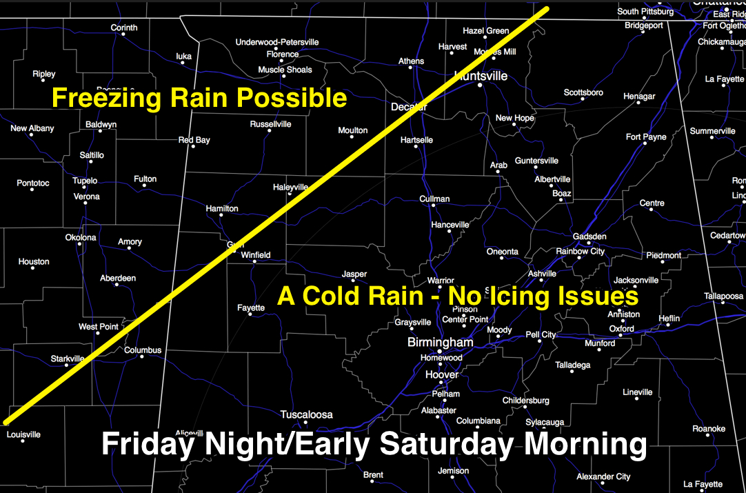
The main risk of freezing rain is west of a line from Vernon to Haleyville to Moulton to Huntsville. Due to the very shallow nature of the cold air, models will have a hard time with this, we we might have to adjust this line one way or another. Clearly the worst of the ice will be west of Alabama, but just be aware that some bridge icing is a very real possibility in this part of our state.
THE DAY SATURDAY: It will be cold and wet, with period of rain and a high only in the 40s. The northwest corner of the state might not get out of the 30s.
WARMER SUNDAY: Sunday will be another day with a huge temperature spread as a warm front moves northward. Places like Tuscaloosa and Birmingham could reach the 60s, but Northwest Alabama will probably hold in the 40s, and over in Northeast Alabama they could hold in the 40s thanks to cold air damming (the wedge… cold air draining in from Georgia). And, the weather stays wet with periods of rain likely over the northern half of the state.
COLD AIR BLAST NEXT WEEK: The rain finally tapers off Monday, followed by a dose of very cold air. Models hint we won’t get out of the 30s Tuesday, and by early Wednesday morning lows will be in the 17-23 degree range. We might see a few snow flurries Monday night or Tuesday morning, but for now that doesn’t look like an issue.
Again, be sure and watch the Weather Xtreme video for all of the maps, graphics, and more details.
NEED HELP WITH YOUR WEATHER RADIO? We will be at Marble City Pharmacy in Sylacauga this afternoon from 3:30 until 6:30 p.m. programming weather radios. You can buy one if you need one, and if you have questions or need help, some see us.
WEATHER BRAINS: Don’t forget you can listen to our weekly 90 minute netcast anytime on the web, or on iTunes. This is the show all about weather featuring many familiar voices, including our meteorologists here at ABC 33/40.
CONNECT: You can find me on all of the major social networks…
Facebook
Twitter
Google Plus
Instagram
I will be doing a program this morning for the kids at the Children’s Hospital of Alabama… look for the next Weather Xtreme video here by 3:00 this afternoon. Enjoy the day…



