Restoring Service after Hurricane Isaias

Restoring Service After Hurricane Isaias

Restoring Service After Hurricane Isaias

Hurricane Isaias left more than 400,000 Alabamians without power. Alabama Power crews along with more than 7,400 resources from 28 states came together to help restore service and get communities back on their feet.

Read More: After Hurricane Isaias, restoring service to Alabama Power customers is a team effort

Posted in ALL POSTS, Partner News Stories | Comments Off on Restoring Service after Hurricane Isaias

Breezy Saturday, Fall Weekend in Store

Daily Weather Briefing
Saturday, October 17, 2026

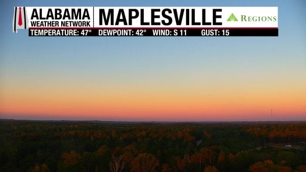
ALABAMA THIS MORNING
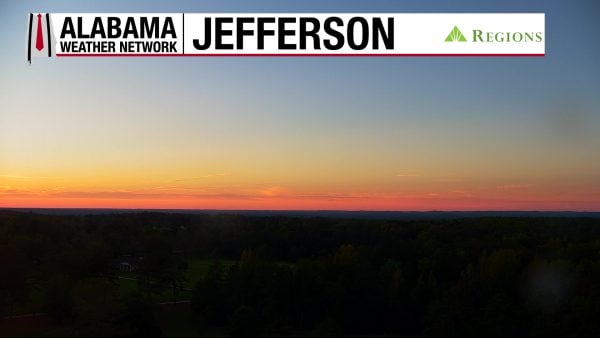
Skies are partly cloudy to mostly clear, and temperatures are in the cool upper 40s and low 50s across the state this morning. Our Regions Skycams in Hoover, Jefferson, and Maplesville show beautiful, bright colors with the Saturday sunrise!

ALABAMA 7 DAY FORECAST
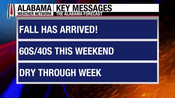
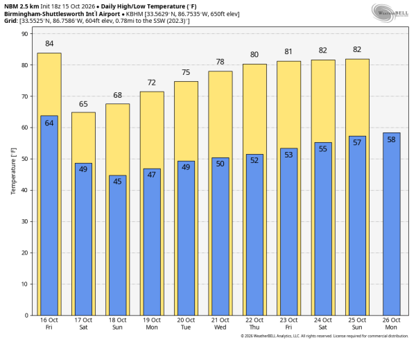
A strong, dry cold front pushed through Alabama yesterday, and much cooler, drier air has been filtering into the state throughout the night. This weekend will feature highs and lows quite seasonable for this time of year with elevated winds today. As we head into next week, an upper-level ridge from the west will cause temperatures to increase each day. Alabama will remain rain-free through the 7-day period.
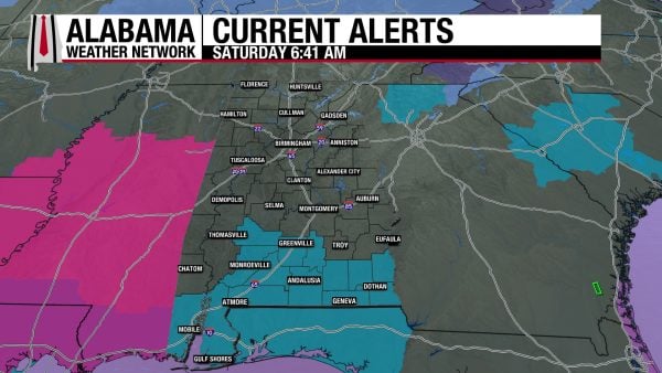

FIRST REAL TASTE OF FALL HAS ARRIVED FOR THE WEEKEND – Oct 17-18
Fall has finally arrived in Alabama. Our chilly lows this morning will rise to the pleasant mid to upper 60s statewide, with parts of south Alabama reaching 70 degrees. Winds in the northern half of the state will blow at 10-15 mph and gust to up to 30 mph. In the south, a Wind Advisory is in effect, as stronger winds of 20-25 mph with gusts up to 40 mph are possible. This poses a threat to ongoing hurricane recovery in the south, as vulnerable trees may fall and cause more downed power lines and power outages, and debris can be blown around and re-block roads.

Winds return to their ambient nature tonight, and lows will fall to the lower 40s north, mid 40s centrally, upper 40s south, and mid 50s on the coast. Northeast Alabama could fall into the upper 30s!

Tomorrow, highs will climb into the upper 60s and low 70s statewide.

PLEASANT START TO THE WEEK – Oct 19-21
Monday through Wednesday will be pleasant, although highs will increase each day thanks to an upper-level ridge building to our west.

On Monday, lows in the morning will be low 40s over the northern half of the state and the mid to upper 40s in the southern half. Very few clouds will allow highs to reach the low 70s statewide in the afternoon.

Tuesday morning won’t be as cold as Monday, with lows in the mid to upper 40s across Alabama. Temperatures will top out in the mid 70s by the afternoon.

On Wednesday, the mid to upper 70s will span over the state.

INCREASING TEMPERATURES CLOSE OUT THE WEEK – Oct 22-23
The upper-level ridge will continue its influence over Alabama as the work week ends.

The low 80s will return on Thursday, with a spread of upper 70s and low 80s highs expected across Alabama.

Highs on Friday will mostly be in the low 80s, with just a few locations clinging to the upper 70s.
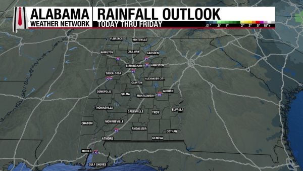

RAINFALL OUTLOOK
Alabama will be completely dry this week!
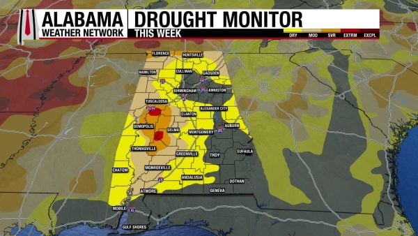

IMPROVED DROUGHT CONDITIONS AFTER ISAIAS RAINS
Hurricane Isaias brought decent rainfall to Alabama last week, bringing the drought conditions in the state down somewhat. Last week, 13.32% of the state was drought-free; that percentage has increased to 28.70% this week. 23.97% of Alabama is experiencing Moderate Drought (D1) conditions, compared to 37.45% last week. Severe Drought (D2) is present in 8.10% of Alabama instead of 11.11% last week, and only 0.75% is experiencing Extreme Drought (D3), compared to 1.18% last week. It’s good to see some relief this week, especially because next week will be very dry and exacerbate the drought once again.

FOOTBALL FORECAST
AUBURN VS. GEORGIA
Auburn travels to Athens to take on Georgia today at 2:30 p.m. CDT. It will be a perfect day for the game; a sunny sky with upper 60s at kickoff, falling into the 60s by the fourth quarter.

BAMA VS. TENNESSEE
Alabama is on the road as they play Tennessee in Knoxville at 2:30 p.m. CDT today. Skies will be sunny and temperatures in the upper 50s at kickoff, low 50s by the fourth quarter.

ALABAMA A&M VS. GRAMBLING STATE
Today is homecoming for Alabama A&M; they host Grambling State at 2:00 p.m. CDT. The sky will be sunny with temperatures in the mid 60s at kickoff, falling into the 50s by the second half.

The weather will be clear and very pleasant for all of the other games across Alabama and the Deep South today.
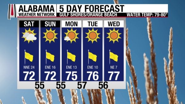

BREEZY BEACH CONDITIONS TODAY, PLEASANT WEEK AHEAD
Yesterday’s cold front has made south and coastal Alabama quite windy today, and winds will blow from the north/northeast at 25 mph today! This has caused the rip current risk to increase to Moderate, and surf height to rise to 2 to 3 feet. Today’s high will be in the low 70s, skies will be mostly sunny, and the UV Index will be high. Winds will decrease some tomorrow, and the coming week will feature sunny skies and highs in the 70s on the coast.


TODAY IN WEATHER HISTORY
October 17, 1989 – The 1989 Loma Prieta Earthquake
At 5:04 p.m. on October 17, 1989, the San Francisco Bay Area was jolted by the magnitude 6.9 Loma Prieta earthquake. The timing made the disaster especially memorable. The San Francisco Giants and Oakland Athletics were preparing for Game 3 of the World Series at Candlestick Park, and millions of people were already watching live television coverage when the shaking began.

The earthquake lasted only about 10 to 15 seconds, but the damage was severe. The rupture occurred along the San Andreas Fault system in the Santa Cruz Mountains, and strong shaking spread across much of Northern California. Communities from Santa Cruz and Watsonville northward through San Jose, Oakland, and San Francisco suffered structural damage, utility failures, fires, and transportation disruptions.

The deadliest single collapse occurred in Oakland, where the double-deck Cypress Street Viaduct on Interstate 880 failed. The upper roadway collapsed onto the lower level, trapping vehicles beneath massive concrete slabs and killing 42 people. On the San Francisco-Oakland Bay Bridge, a section of the upper deck also collapsed onto the lower roadway, killing one person and forcing the bridge to close.

San Francisco’s Marina District suffered some of the most dramatic damage. Buildings constructed on soft fill experienced severe shaking, several structures collapsed or tilted, and broken gas lines fueled fires that spread through the neighborhood. Firefighters struggled with damaged water mains and were forced to use alternative water sources while residents and emergency crews worked to rescue people from damaged buildings.

The earthquake killed 63 people, injured nearly 3,800, and left thousands temporarily homeless. Damage reached billions of dollars, and major highways, bridges, homes, businesses, and public infrastructure required years of repair and rebuilding. The disaster also exposed serious weaknesses in older elevated freeways and structures built on soft ground, leading to major changes in earthquake engineering and transportation planning across California.

The Loma Prieta earthquake became one of the defining natural disasters of modern California history. Its destruction was immense, but the extraordinary coincidence of the World Series meant that cameras were already rolling, making it one of the most widely witnessed earthquakes ever experienced in real time.
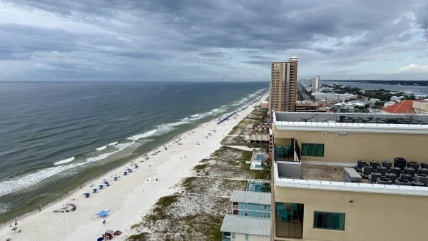

IMAGE OF THE DAY
Skywatcher Michael Wildman sent in a gloomy photo from Gulf Shores around lunchtime yesterday.


Posted in Alabama's Weather, ALL POSTS, Current Watches | Comments Off on Breezy Saturday, Fall Weekend in Store

Colder Air Rolls Into Alabama Tonight; Fine Fall Weekend Ahead

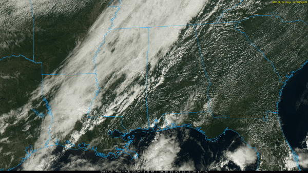
ON THE MAP: A cold front is near I-59 (Tuscaloosa to Birmingham to Gadsden) at mid-afternoon; behind the front temperatures are in the upper 50s and low 60s with a very cool northwest wind. The front will move quickly southward, reaching the Gulf Coast by midnight. Showers will remain few and far between, but the sky will be mostly cloudy tonight in many areas as the cool air rolls into the Deep South.

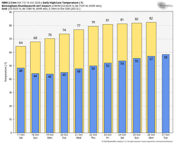
The coolest air so far this season will settle into Alabama for the weekend. Expect highs in the 60s, lows mostly in the 40s, and a sun filled sky both days.

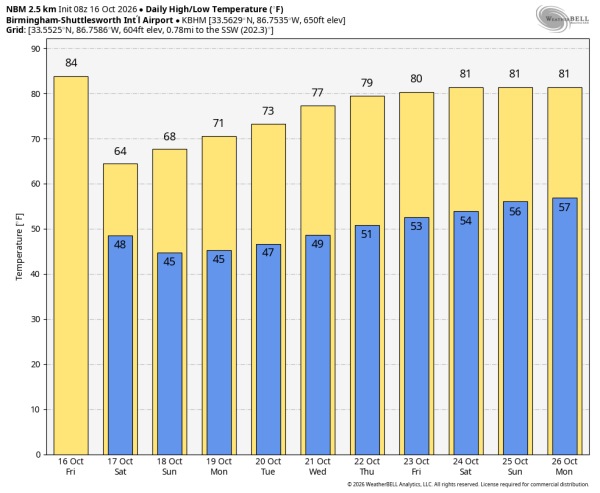
NEXT WEEK: Dry weather continues with a slow warming trend. Afternoon highs will be close 80 degrees by the end of the week.. See the video briefing for maps, graphics, and more details.

TROPICS: The Atlantic basin is quiet and tropical storm formation is not expected for at least the next seven days.

FOOTBALL WEATHER: You might consider a jacket for tonight’s high school games… temperatures will fall through the 50s during the games with a brisk north wind.

Auburn travels to Athens to take on Georgia tomorrow (2:30p CT kickoff). It will be a perfect day for the game; a sunny sky with upper 60s at kickoff, falling into the 60s by the fourth quarter.

Alabama will be on the road as well… they play Tennessee in Knoxville (2:30p CT kickoff). A sun filled sky, temperatures in the upper 50s at kickoff, low 50s by the fourth quarter.

Tomorrow is homecoming for Alabama A&M; they host Grambling State (2:00p CT kickoff). The sky will be sunny with temperatures in the mid 60s at kickoff, falling into the 50s by the second half.

The weather will be clear and very pleasant for all of the other games across Alabama and the Deep South tomorrow.

ON THIS DATE IN 1999: Hurricane Irene moved across the Florida Keys producing heavy rainfall, strong winds, and high waves. A gust 102 mph was reported in Big Pine Key.

Look for my next video briefing here by 6:00 a.m. Monday… enjoy the weekend!

Posted in Alabama's Weather, ALL POSTS | Tagged | Comments Off on Colder Air Rolls Into Alabama Tonight; Fine Fall Weekend Ahead

Are you prepared for severe weather?


Severe weather can develop quickly in Alabama – from tornadoes to flash flooding and damaging storms. Being prepared before a storm hits can make all the difference. Check out safety tips and steps you can take now to protect yourself and your family when severe weather hits.

Read the full story here.

Posted in ALL POSTS, Partner News Stories | Comments Off on Are you prepared for severe weather?

Focused on What Matters…Serving You

Severe weather can strike at any time — and when it does, reliable power matters more than ever. Behind the scenes, Alabama Power crews, technology and ongoing grid improvements are working to keep the lights on and respond quickly when storms hit.
Read how they stay focused on serving you here.

Posted in ALL POSTS, Partner News Stories | Comments Off on Focused on What Matters…Serving You

Cold Front Arrives Today; Cool, Dry Weekend Ahead

FRIDAY FRONT: A cold front will pass through Alabama later today, and it will set up a big thermal contrast. By mid to late afternoon, temperatures will range from the upper 60s across the Tennessee Valley to the upper 80s at places like Montgomery and Dothan. We expect nothing more than small, isolated showers with the front… most communities will stay dry.

Once the front passes, north winds will increase with gusts to 25 mph this afternoon and early tonight with falling temperatures.

The coolest air so far this season settled into the Deep South for the weekend. Expect highs in the 60s, lows mostly in the 40s, and a sun filled sky both days.

NEXT WEEK: Dry weather continues with a slow warming trend. Afternoon highs will be close 80 degrees by the end of the week.. See the video briefing for maps, graphics, and more details.

TROPICS: The Atlantic basin is quiet and tropical storm formation is not expected for at least the next seven days.

FOOTBALL WEATHER: You might consider a jacket for tonight’s high school games… temperatures will fall through the 50s during the games with a brisk north wind.

Auburn travels to Athens to take on Georgia tomorrow (2:30p CT kickoff). It will be a perfect day for the game; a sunny sky with upper 60s at kickoff, falling into the 60s by the fourth quarter.

Alabama will be on the road as well… they play Tennessee in Knoxville (2:30p CT kickoff). A sun filled sky, temperatures in the upper 50s at kickoff, low 50s by the fourth quarter.

Tomorrow is homecoming for Alabama A&M; they host Grambling State (2:00p CT kickoff). The sky will be sunny with temperatures in the mid 60s at kickoff, falling into the 50s by the second half.

The weather will be clear and very pleasant for all of the other games across Alabama and the Deep South tomorrow.

ON THIS DATE IN 1999: Hurricane Irene moved across the Florida Keys producing heavy rainfall, strong winds, and high waves. A gust 102 mph was reported in Big Pine Key.

Look for the next video briefing here by 3:00 this afternoon… enjoy the day!

Posted in Alabama's Weather, ALL POSTS | Tagged | Comments Off on Cold Front Arrives Today; Cool, Dry Weekend Ahead

Cold Front Arrives Tomorrow; Cool Weekend Ahead

HOT OCTOBER AFTERNOON: Temperatures are in the 85-90 degree range across most of Alabama this afternoon with a sunny sky. Tonight will be clear with a low in the 60s.

FRIDAY FRONT: A cold front will pass through the state tomorrow, generally in dry fashion. Any showers should be small and very isolated. The front will set up a big thermal contrast… tomorrow afternoon temperatures will range from the upper 60s at Florence to the upper 80s over South Alabama. A brisk north wind will develop behind the front in the cooler air.

The coolest air so far this season will settle into the Deep South tomorrow night. The weekend will feature morning lows mostly in the 40s, with highs in the 60s. Sunny days, clear nights. A picture perfect autumn weekend.

NEXT WEEK: Dry weather continues through the week with a slow warming trend; highs will be near 80 by the end of the week. See the video briefing for maps, graphics, and more details.

TROPICS: The Atlantic basin is quiet and tropical storm formation is not expected for at least the next seven days.

FOOTBALL WEATHER: UAB hosts East Carolina tonight at Protective Stadium (6:30p CT kickoff). A clear sky, about 84 degrees at kickoff. Temperatures will fall into the 70s through most of the game.

Auburn travels to Athens to take on Georgia Saturday (2:30p CT kickoff). It will be a perfect day for the game; a sunny sky with upper 60s at kickoff, falling into the 60s by the fourth quarter.

Alabama will be on the road as well… they play Tennessee in Knoxville (2:30p CT kickoff). A sun filled sky, temperatures in the upper 50s at kickoff, low 50s by the fourth quarter.

Saturday is homecoming for Alabama A&M; they host Grambling State (2:00p CT kickoff). The sky will be sunny with temperatures in the mid 60s at kickoff, falling into the 50s by the second half.

The weather will be clear and very pleasant for all of the other games across Alabama and the Deep South Saturday.

ON THIS DATE IN 1984: The Monday Night Football game in Denver was played in a raging blizzard. 15 inches of snow fell with up to 34 inches reported in the nearby mountains. The Air Force Academy canceled classes for the first time in its’ recorded history.

ON THIS DATE IN 1999: Hurricane Irene made landfall in the Florida Keys near Key West, with maximum sustained winds estimated at 75 mph.

Look for the next video briefing here by 6:00 a.m. tomorrow…

Posted in Alabama's Weather, ALL POSTS | Tagged | Comments Off on Cold Front Arrives Tomorrow; Cool Weekend Ahead

Coolest Air So Far This Season Arrives Tomorrow Night

MORE RECORDS: Afternoon highs across Alabama today will rise into the upper 80s and low 90s, and this should be the third consecutive day with record highs for some of the major reporting stations. The sky will be mostly sunny as dry air stays in place.

FRIDAY FRONT: A cold front will pass through the state tomorrow, generally in dry fashion. Any showers should be small and very isolated. The front will set up a big thermal contrast… tomorrow afternoon temperatures will range from the upper 60s at Florence to the upper 80s over South Alabama. A brisk north wind will develop behind the front in the cooler air.

The coolest air so far this season will settle into the Deep South tomorrow night. The weekend will feature morning lows mostly in the 40s, with highs in the 60s. Sunny days, clear nights. A picture perfect autumn weekend.

NEXT WEEK: Dry weather continues through the week with a slow warming trend; highs will be near 80 by the end of the week. See the video briefing for maps, graphics, and more details.

TROPICS: The Atlantic basin is quiet and tropical storm formation is not expected for at least the next seven days.

FOOTBALL WEATHER: UAB hosts East Carolina tonight at Protective Stadium (6:30p CT kickoff). A clear sky, about 84 degrees at kickoff. Temperatures will fall into the 70s through most of the game.

Auburn travels to Athens to take on Georgia Saturday (2:30p CT kickoff). It will be a perfect day for the game; a sunny sky with upper 60s at kickoff, falling into the 60s by the fourth quarter.

Alabama will be on the road as well… they play Tennessee in Knoxville (2:30p CT kickoff). A sun filled sky, temperatures in the upper 50s at kickoff, low 50s by the fourth quarter.

Saturday is homecoming for Alabama A&M; they host Grambling State (2:00p CT kickoff). The sky will be sunny with temperatures in the mid 60s at kickoff, falling into the 50s by the second half.

The weather will be clear and very pleasant for all of the other games across Alabama and the Deep South Saturday.

ON THIS DATE IN 1984: The Monday Night Football game in Denver was played in a raging blizzard. 15 inches of snow fell with up to 34 inches reported in the nearby mountains. The Air Force Academy canceled classes for the first time in its’ recorded history.

ON THIS DATE IN 1999: Hurricane Irene made landfall in the Florida Keys near Key West, with maximum sustained winds estimated at 75 mph.

Look for the next video briefing here by 3:00 this afternoon… enjoy the day!

Posted in Alabama's Weather, ALL POSTS | Tagged | Comments Off on Coolest Air So Far This Season Arrives Tomorrow Night

Record Warm Possible Again Tomorrow; Cold Front Arrives Friday

HOT: Temperatures are in the upper 80s and low 90s across Alabama this afternoon, right at record levels for October 14. Tonight will be mostly clear with a low in the 60s.

Afternoon highs will remain very close to 90 degrees across Alabama tomorrow… a dry air means no rain and a mostly sunny sky.

A cold front will pass through the state Friday, generally in dry fashion. Any showers should be small and very isolated, and due to the front there will be a big thermal contrast across the state. Temperatures Friday afternoon will range from near 70 across the Tennessee Valley of North Alabama to the upper 80s across the southern counties.

WEEKEND COOLDOWN: The coolest air so far this season will roll into the Deep South over the weekend. Expect morning lows in the 45-52 degree range, with highs in the upper 60s and low 70s. The weather stays dry with sunny days and clear nights.

Dry weather continues through all of next week with a slow warming trend… See the video briefing for maps, graphics, and more details.

TROPICS: The Atlantic basin is quiet and tropical storm formation is not expected for at least the next seven days.

FOOTBALL WEATHER: UAB hosts East Carolina tomorrow night at Protective Stadium (6:30p CT kickoff). A clear sky, about 84 degrees at kickoff. Temperatures will fall into the 70s through most of the game.

Auburn travels to Athens to take on Georgia Saturday (2:30p CT kickoff). It will be a perfect day for the game; a sunny sky with low 70s at kickoff, falling into the 60s by the fourth quarter.

Alabama will be on the road as well… they play Tennessee in Knoxville (2:30p CT kickoff). A sun filled sky, temperatures in the low to mid 60s at kickoff, upper 50s by the fourth quarter.

Saturday is homecoming for Alabama A&M; they host Grambling State (2:00p CT kickoff). The sky will be sunny with temperatures in the upper 60s at kickoff, falling into the 50s by the second half.

The weather will be clear and very pleasant for all of the other games across Alabama and the Deep South Saturday.

ON THIS DATE IN 1909: At least three violent tornadoes touched down across North Alabama. Seven people were killed in a tornado that moved from near Woodville to just south of Scottsboro. Three more were killed by a tornado just south of Russellville in Franklin County.

Look for the next video briefing here by 6:00 a.m. tomorrow…

Posted in Alabama's Weather, ALL POSTS | Tagged | Comments Off on Record Warm Possible Again Tomorrow; Cold Front Arrives Friday

Afternoon Highs Near Record Levels Today/Tomorrow; Much Cooler By The Weekend

HOT AFTERNOONS: While mornings remain pleasant, afternoon highs will remain very close to 90 degrees across Alabama today and tomorrow… right at record levels for mid-October. Dry air means no rain and a mostly sunny sky both days.

A cold front will pass through the state Friday, generally in dry fashion. Any showers should be small and very isolated, and due to the front there will be a big thermal contrast across the state. Temperatures Friday afternoon will range from near 70 across the Tennessee Valley of North Alabama to the upper 80s across the southern counties.

WEEKEND COOLDOWN: The coolest air so far this season will roll into the Deep South over the weekend. Expect morning lows in the 45-52 degree range, with highs in the upper 60s and low 70s. The weather stays dry with sunny days and clear nights.

Dry weather continues through all of next week with a slow warming trend… See the video briefing for maps, graphics, and more details.

AIR QUALITY: There is a “code orange” air quality alert for the Birmingham metro today (Jefferson and Shelby counties) due to ground level ozone. This means air quality could be “unhealthy for sensitive groups”. This mainly impacts people with respiratory conditions: asthma, COPD, bronchitis, or emphysema.

TROPICS: The Atlantic basin is quiet and tropical storm formation is not expected for at least the next seven days.

FOOTBALL WEATHER: UAB hosts East Carolina tomorrow night at Protective Stadium (6:30p CT kickoff). A clear sky, about 84 degrees at kickoff. Temperatures will fall into the 70s through most of the game.

Auburn travels to Athens to take on Georgia Saturday (2:30p CT kickoff). It will be a perfect day for the game; a sunny sky with low 70s at kickoff, falling into the 60s by the fourth quarter.

Alabama will be on the road as well… they play Tennessee in Knoxville (2:30p CT kickoff). A sun filled sky, temperatures in the low to mid 60s at kickoff, upper 50s by the fourth quarter.

Saturday is homecoming for Alabama A&M; they host Grambling State (2:00p CT kickoff). The sky will be sunny with temperatures in the upper 60s at kickoff, falling into the 50s by the second half.

The weather will be clear and very pleasant for all of the other games across Alabama and the Deep South Saturday.

ON THIS DATE IN 1909: At least three violent tornadoes touched down across North Alabama. Seven people were killed in a tornado that moved from near Woodville to just south of Scottsboro. Three more were killed by a tornado just south of Russellville in Franklin County.

Look for the next video briefing here by 4:00 this afternoon… enjoy the day!

Posted in Alabama's Weather, ALL POSTS | Tagged | Comments Off on Afternoon Highs Near Record Levels Today/Tomorrow; Much Cooler By The Weekend