(Time lapse at 8x normal speed, stratocumulus clouds along dryline, then dryline itself, at Smith Lake facing west.)
Brian Peters and I did a quick storm chase today up I-65 to Exit 299 then met the line of storms on the east side of Smith Lake. We were a little sheltered from the SW winds by a mountain to our west at our first position, and our highest wind gust was only 38 mph. However, Brian’s car thermometer (those tend to be pretty accurate as long there is air movement, and 20-40 mph winds takes care of that) surged from 67 up to 78 degrees at one point, for only a minute or two. If this was correct, it was likely a “heat burst”, when a thunderstorm downdraft transports air to the ground from aloft and it warms on the way down due to compression. This is rare, since usually a warm parcel like this would be buoyant and never reach the ground. But it occasionally occurs, and the air today was rather stable at low levels, and dynamics could have forced the air to the surface despite its buoyancy. Cool.
The storms today formed ahead of what one could call a dryline, basically a front with much drier air behind it. It’s really a cold front, but since the dewpoint drop behind it was so dramatic and the sun came out, temperatures went up, so it doesn’t seem like a cold front.
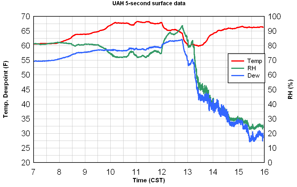
Take a look at the temp/RH/dewpoint chart from UAH as the dryline moved by. The dewpoint dropped from 62 to 41 in about 45 minutes! That’s rapid drying. The dewpoint is now in the 20s.