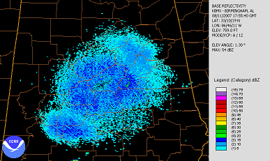
Someone posed the question on the blog about why we’ve been seeing so much “blue”, or low reflectivity return, on the radar lately. There have been almost no clouds or rain. I think it is related to the extreme heat.
Normally, one sees a growing area of “blue” around the radar after sunset, due to insects coming out, and the radar beam getting bent down toward the ground due to the temperature inversion. During the day, the radar beam has more normal propagation, and you normally see less light return around the radar.
Lately, with the very hot temperatures, the boundary layer, or the layer of the atmosphere near the ground in which turbulence and friction occur, has been very deep. So, bugs, dust, and even birds are carried higher aloft even in the daytime. Also, with the very hot temperatures causing rapid decrease in temperature with height, there is a lot of turbulence near the ground, which can also sometimes be picked up by the radar.
The radar image from Saturday at 1755 GMT (12:55 pm CDT) shows returns up to 10 dBZ as far away as Cullman County. And, this is not the lowest elevation scan of the radar, and the beam is near 10,000 feet there.
The UAH MIPS wind profiler, a type of vertically-pointing radar designed for more detailed measurements at low levels, also shows the deep boundary layer due to the heat. Note how the layer of return increases rapidly with height between 14 and 16 GMT (9 and 11 am), while the temperature is rising quickly. This is probably a combination of turbulence, insects, dust, and even birds being carried to great heights in the turbulent layer.

The profiler can detect vertical air motions, also. Note that during the hot part of the day, up and down motions of up to 2 m/s (about 4 mph) change rapidly. A 4 mph updraft could easily carry small insects aloft.