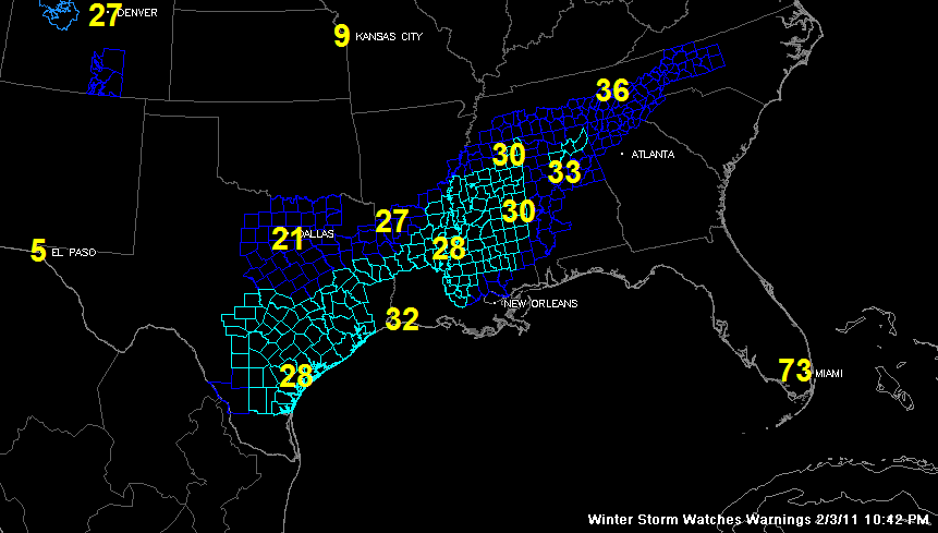
This map shows most of the winter weather advisories (in blue) and winter storm warnings (in teal) across much of the United State. I say most, because it is missing the winter storm warning over the Rio Grande Valley of Deep South Texas around Brownville and the winter storm warnings for much of southwestern Louisiana from the NWS Lake Charles.
It also shows 10 p.m. temperatures at selected cities.
Looking at some point forecasts to the west and north of Alabama.
Brownsville…1 to 2 inches of snow and ice accumulations through noon Friday…winter storm warning in effect. Also a hard freeze warning tonight with lows between 25-27F.
Houston…light snow, sleet and freezing rain through 9 a.m. Friday. 1 to 2 inches of snow or ice in the Houston area with isolated 3 and 4 inch amounts. Temperatures remaining below freezing through the event with hazardous travel likely Friday morning. Winter storm warning in effect.
Dallas/Fort Worth…winter weather advisory…1 to 3 inches of snow overnight from a passing upper level disturbance.
Alexandria LA…winter storm warning….1 to 2 inches of sleet and snow with 1/4 inch of freezing rain possible. Icing expected all the way to the coast
Baton Rouge…1/2 inch of ice overnight…winter storm warning in effect.
Jackson/Starkville…1/2 inch with isolated higher ice accumulations…winter storm warning in effect.
Chattanooga/Knoxille…winter weather advisory…trace to 1/10th inch of freezing rain…little or no snow accumulation.