*Busy night in the weather office… but not as busy as Monday nights when we record WeatherBrains. Had a fun show last night if you missed it; had a guest from Australia, where are enjoying summer warmth now, a meteorologist from the Johnson Space Flight Center in Houston, a guest TV meteorologist from Michigan, and the usual shenanigans. Listen to the show here if you want, or on iTunes.
*A quick peek at the 00Z guidance suggests no major changes are needed at this point in the forecast… a general 1-2 inch snow seems likely for much of North Alabama, with potential for a few pockets of 3 inch totals in scattered spots. There could be a little snow accumulation south of I-20 as well; maybe an inch or so.
*Kevin Laws of the Birmingham NWS just chimed in on the internal chat, and mentions that forcing is getting a little stronger with this system thanks to a decent band of strengthening low level frontogenesis (850-700mb) and upper level instability (from 700 to 500mb). Also, they are considering adding another row of counties on the south end of the existing Winter Storm Watch (counties like Dallas, Autauga, Elmore, Coosa, Tallapoosa, and Chambers). The great search in this kind of event is that “sweet spot” where the best combination of dynamic lift and moisture happens with sufficient depth of cold air for snow. I am not sure we will get one in this event since it is not a classic Gulf low lifting northeastward, but once the system really gets on the board tomorrow morning we will have a good look.
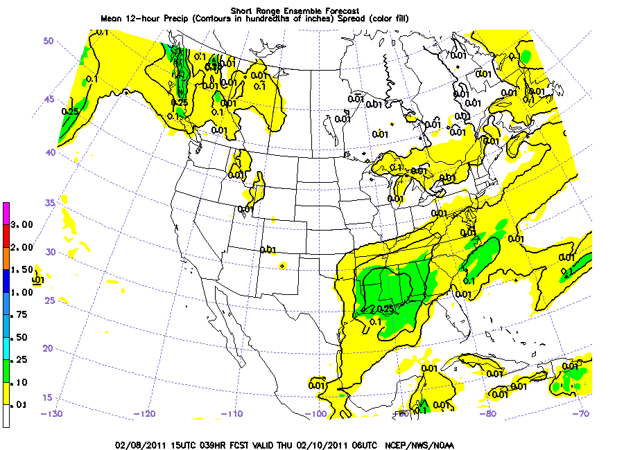
Below is the output of the SREF valid at midnight tomorrow night, suggesting around 1-2.5 inches of snow around here…
BOTTOM LINE: Below is text I just posted to our seven day forecast page… pretty much summing up the discussion from earlier today here on the blog…
This is not what most would call a major winter storm system… we are talking an inch or two of snow at most places across North Alabama. And, the good news is that there is no freezing rain involved this time, meaning no concern of ice accumulations. So, it will be a short term inconvenience more than anything else. And, the rapid movement of the system means the snow will come and go in a hurry.
TIMING: Snow could begin to accumulate around the Muscle Shoals area of Northwest Alabama as early as 5:00 p.m… but for most places the best chance of accumulating snow will come in the 6:00 p.m. to 2:00 a.m. time frame. The snow will initially fall with surface temperatures above freezing, so the roads will be just wet, and we don’t expect any driving problems before 6:00 p.m. We should also note than the precipitation will most likely begin as rain over parts of West-Central Alabama… places like Tuscaloosa, Eutaw, and Greensboro could see a period of rain before snow flakes begin to fall. All of the really significant snow should be out of Alabama by 3:00 a.m. tomorrow… although a few flurries could linger to about sunrise.
HOW MUCH? I still think the general idea of 1-2 inches north of I-20 looks good. There could be a few pockets of heavier snow, perhaps enhanced by terrain, so our forecast will still mention 1 to 3 inches.The deepest moisture will be down over South Alabama, but it will all be rain down there. Around one inch of snow is possible for places like Tuscaloosa, Calera, and Talledega, and a few snow flakes could be seen as far south as Livingston, Clanton, and Roanoke, and the idea of some accumulation that far south is not totally off the board.
TRAVEL ISSUES: The greatest chance of road problems will come generally in the time frame from 8:00 Wednesday night to around 8:00 a.m. Thursday. The main issue, as usual, will be icy spots on bridges and overpasses. But some black top road surfaces, especially higher terrain, could become slick in spots where heavier snow falls. The temperature should be above freezing by 9:00 a.m. tomorrow and icy spots will melt away during the midday hours.
REMEMBER: With any winter weather event in Alabama there will be surprises… so watch for any last minute forecast changes later this morning.