**DANGEROUSLY COLD AIR MOVING IN** See Bill’s post below for details on possible snow Thursday.
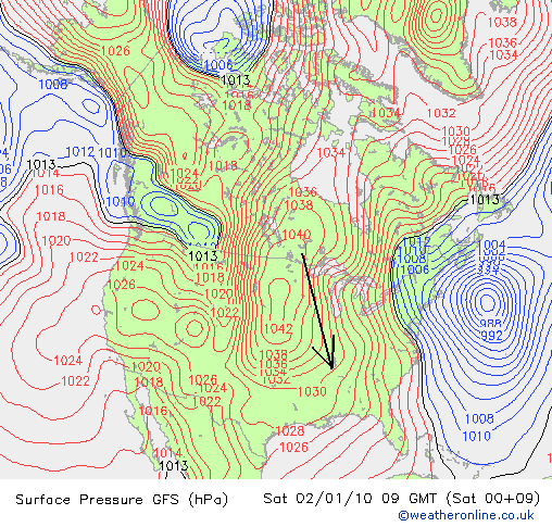
The cold air is arriving. It was still at or below freezing from BHM northward at noon, and areas north of 278 may stay below freezing all day. But, with north winds continuing around the big high pressure area to our NW, the air over Alabama will slowly get colder during the next couple of days. Here are trajectories showing where our air is coming from.
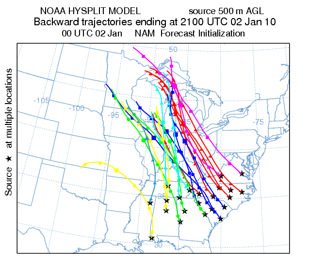
The air that is in BHM this afternoon was in south-central Minnesota yesterday evening. Minneapolis had a high yesterday of 6 degrees, meaning that air has to warm up by 27 degrees due to the warming effects of sunshine and heat released from the ground, counteracting any cooling due to radiation or snow melt/sublimation, for us to get above freezing today. About 50% of the trip from Minnesota to BHM is over snow pack.
Perhaps the most alarming thing about this cold air outbreak will be its duration. Here are graphs of hourly temperatures from 3 pm today through 6 pm Friday for Birmingham, Huntsville, Montgomery, and Atlanta.
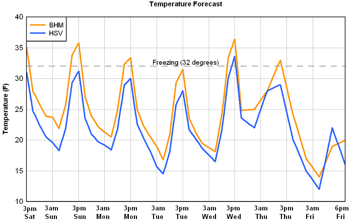
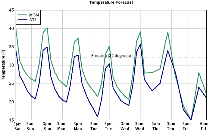
A couple of things here. First of all, all major models are in general agreement on this pattern. But, the Canadian and the European are slightly warmer. But, we’re talking about overall differences of 2-3 degrees, so no big changes. Notice we keep getting colder every day until Wednesday, ahead of the next upper disturbance (that could bring some snow). After a brief warming, temperatures really drop by Friday.
Also notice that none of the cities reaches 40 degrees for the next week except Montgomery, and only barely there. At BHM, we expect lows 15 to 20 most mornings, with highs 30 to 35. By Friday, high temperatures may be in the 20s. Some of the colder spots in north Alabama will likely see lows in the single digits.
Also, BHM is only expected to be above freezing for about 18 of the next 148 hours, meaning we’ll be below freezing 88% of the time. About the same in ATL, 99% in HSV, and 76% in MGM.
If the above forecast is even close for BHM, this will be in the bottom 2% for weekly average temperatures in BHM since 1896. Some of the only weeks colder than this one that pop up include weeks in January 1940; February 1899; January 1985; December 1989; and January 1982.
This is a serious situation. This type of long-duration cold air will allow pipes that may not have frozen for many years to freeze. Turn off water to outside faucets and drain them, and wrap any other pipes. Try to conserve energy by opening curtains on south-facing windows during the day to let sunlight in, while closing all curtains at night and on the north side of the house all the time. Also, if you have any leaky doors or windows, put towels or something along draft areas. Wear warm clothes in the house so you can turn down the thermostat if possible. When you go outside, make sure and dress in layers, including hats, gloves, and a heavy coat. As far as pets, bring them inside at night if at all possible. Most dogs and cats around here are simply not up to handling these temperatures, despite what some people say. If they absolutely have to stay outside, make sure their doghouse door faces south or east, put extra blankets inside, and hang a curtain (towel, etc.) over the door. Just make sure the dog will go in/out the door with the curtain first! But, if possible, bring them inside the house! Also, make sure you check on any elderly family, neighbors, etc., and make sure they have plenty of warmth.
We’ll keep you updated on the cold air this weekend and into next week on the blog, and have more on the possible snowstorm Thursday also.